
Scottville, Michigan facts for kids
Quick facts for kids
Scottville, Michigan
|
|
|---|---|
|
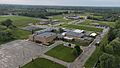
From top, clockwise:
Main Street facing the city hall toward US 10, McPhail Field, Scottville School |
|

Location within Mason County
|
|

Scottville, Michigan
Location in Michigan

Scottville, Michigan
Location in the United States
|
|
| Country | United States |
| State | Michigan |
| County | Mason |
| Founded | 1874 |
| Platted | 1882 |
| Incorporated | 1889 (village) 1907 (city) |
| Government | |
| • Type | City commission |
| Area | |
| • Total | 1.49 sq mi (3.86 km2) |
| • Land | 1.49 sq mi (3.86 km2) |
| • Water | 0.00 sq mi (0.00 km2) |
| Elevation | 692 ft (211 m) |
| Population
(2020)
|
|
| • Total | 1,356 |
| • Density | 910.07/sq mi (351.40/km2) |
| Time zone | UTC-5 (Eastern (EST)) |
| • Summer (DST) | UTC-4 (EDT) |
| ZIP Code |
49454
|
| Area code(s) | 231 |
| FIPS code | 26-72080 |
| GNIS feature ID | 1621550 |


Scottville is a small city located in Mason County, which is in the state of Michigan in the United States. In 2020, about 1,356 people lived there.
Contents
History of Scottville
Scottville first appeared on maps in 1874. It was a stop along the Pere Marquette Railway, a train line. At first, it was called "Mason Center" because it was in the middle of Mason County.
Later, its name changed to "Sweetland." This was to honor James Sweetland, who built a sawmill there in 1878. A sawmill is a place where logs are cut into lumber.
In 1882, a man named Hiram Scott planned out the town's streets and lots. This process is called "platting." He won the chance to rename the town "Scottville" after winning a coin toss!
Scottville officially became a village in 1889. It then became a city in 1907.
Cool Cities Program
On July 23, 2007, Michigan's Governor, Jennifer Granholm, made an exciting announcement. Scottville was chosen to join the "Cool Cities Michigan Main Street" program. This program helps communities grow and create new jobs. Scottville received special help for five years to improve its downtown area.
Geography of Scottville
Scottville is located in the central part of Mason County. It is about 8 miles (13 km) east of Ludington and Lake Michigan. It is also 3 miles (5 km) west of Custer.
The city covers a total area of about 1.49 square miles (3.86 square kilometers). All of this area is land, with no large bodies of water inside the city limits.
Population and People
| Historical population | |||
|---|---|---|---|
| Census | Pop. | %± | |
| 1890 | 147 | — | |
| 1900 | 554 | 276.9% | |
| 1910 | 891 | 60.8% | |
| 1920 | 1,045 | 17.3% | |
| 1930 | 1,002 | −4.1% | |
| 1940 | 1,162 | 16.0% | |
| 1950 | 1,142 | −1.7% | |
| 1960 | 1,245 | 9.0% | |
| 1970 | 1,202 | −3.5% | |
| 1980 | 1,241 | 3.2% | |
| 1990 | 1,287 | 3.7% | |
| 2000 | 1,266 | −1.6% | |
| 2010 | 1,214 | −4.1% | |
| 2020 | 1,356 | 11.7% | |
| U.S. Decennial Census | |||
In 2010, there were 1,214 people living in Scottville. Most residents were White (about 93%). About 5% of the population identified as Hispanic or Latino.
The average age of people in Scottville was about 35 years old. About 28% of the residents were under 18 years old.
Education in Scottville
Scottville is home to West Shore Community College. This college offers two-year programs and was started in 1967.
For younger students, Scottville is part of the Mason County Central Schools district. This district provides education from kindergarten through 12th grade.
Notable People from Scottville
- Maynard James Keenan, a famous musician
Images for kids
-
Mason County Central schools

See also
 In Spanish: Scottville para niños
