Seguam Island facts for kids
Quick facts for kids Seguam Island |
|
|---|---|
 |
|
| Highest point | |
| Elevation | 3,458 ft (1,054 m) |
| Geography | |
| Location | Aleutian Islands, Alaska, US |
| Topo map | USGS Seguam |
| Geology | |
| Mountain type | Stratovolcanoes |
| Last eruption | May to August 1993 |
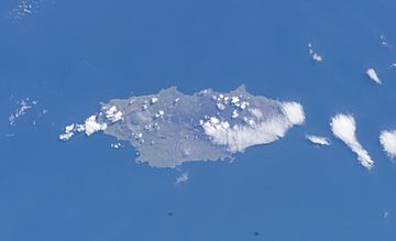
Seguam Island (Aleut: Saĝuugamax; Russian: Остров Сигуам) is a small volcanic island in the Andreanof Islands group. It is part of the Aleutian Islands in Alaska, US. This island is shaped like an oval and has many mountains.
Seguam Island covers an area of about 80 square miles (207 square kilometers). It is about 16 miles (26 kilometers) long and 6.8 miles (11 kilometers) wide. According to the 2000 census, only one person lived on the island!
Contents
About Seguam Island
Seguam Island is located in the Aleutian Islands, a long chain of islands in Alaska. These islands are famous for their many volcanoes. Seguam Island is a great example of a volcanic island.
Geography and Size
The island's shape is like an oval, and it is very mountainous. Its highest point is Pyre Peak, which is part of a volcano. The island's size makes it a small but important part of the Aleutian chain.
Who Lives There?
In the year 2000, only one person was recorded as living on Seguam Island. This shows how remote and wild this part of Alaska can be. It's a place where nature truly takes center stage.
Volcanoes of Seguam Island
Seguam Island is made up of several stratovolcanoes. A stratovolcano is a tall, cone-shaped volcano built up by many layers of hardened lava, ash, and rocks. Think of it like a giant, layered cake!
Calderas and Cones
The island has two large calderas. A caldera is a big, bowl-shaped hollow that forms when the ground collapses after a volcanic eruption. Inside each of these calderas, there are smaller, central volcanic cones. These cones are where new eruptions often happen.
Eruption History
Since the late 1700s, about 10 volcanic eruptions have been recorded on Seguam Island. The most recent eruption happened in 1993, between May and August. All the recent volcanic activity has taken place at Pyre Peak. This peak is the highest point on the island and is located within the western caldera.
Types of Eruptions
The eruptions at Pyre Peak have mostly been explosive eruptions. This means they release a lot of ash, gas, and rock into the air very quickly. These eruptions have also produced basaltic lava flows. Basaltic lava is a type of lava that flows easily, like thick syrup, when it's hot.
 | Delilah Pierce |
 | Gordon Parks |
 | Augusta Savage |
 | Charles Ethan Porter |

