
Selden, New York facts for kids
Quick facts for kids
Selden, New York
|
|
|---|---|

Suffolk County Community College
|
|
 |
|

Selden, New York
Location in Long Island

Selden, New York
Location in New York
|
|
| Country | United States |
| State | New York |
| County | Suffolk |
| Area | |
| • Total | 4.55 sq mi (11.78 km2) |
| • Land | 4.55 sq mi (11.78 km2) |
| • Water | 0.00 sq mi (0.00 km2) |
| Elevation | 89 ft (27 m) |
| Population
(2020)
|
|
| • Total | 21,262 |
| • Density | 4,673.99/sq mi (1,804.66/km2) |
| Time zone | UTC−05:00 (Eastern Time Zone) |
| • Summer (DST) | UTC−04:00 |
| ZIP Code |
11784
|
| Area code(s) | 631, 934 |
| FIPS code | 36-66212 |
| GNIS feature ID | 0964814 |
Selden is a community in Suffolk County, New York, United States. It is known as a hamlet and a census-designated place. This means it's a small community that isn't officially a town or city, but the government counts its population. In 2010, about 19,851 people lived there.
Contents
History of Selden
Early Days and Captain Daniel Roe
Farmers first settled in the area now called Selden in the mid-1700s. They called it "Westfield." One important early resident was Captain Daniel Roe (1740–1820). He fought in the French and Indian War and was a captain in the American Revolutionary War. A local road, Captain Daniel Roe Highway, is named after him.
Captain Roe built his house in Selden before the Revolutionary War. He is buried in a small family cemetery near Middle Country Road.

During the Revolutionary War, Roe supported the American side (the Patriots). In 1776, he led a group against his cousin, Richard Miller. Miller was a Tory (someone loyal to Britain) and a soldier for the British. When Miller rode past Roe's house, Roe's men stopped him. Miller tried to escape but was shot and died in Roe's house.
How Selden Got Its Name
In 1815, the first school district for Westfield was created. It was later renumbered District 12. This district lasted until 1957.
When a post office opened in 1852, the name "Westfield" was already in use by another community in New York. A lawyer named Henry Selden offered a reward if the community named itself after him. So, the name "Selden" was chosen. It's not clear if he ever gave the reward. Some reports say Selden and another lawyer bought land in the hamlet to develop it around that time.
By 1885, Selden had 88 residents and a church. Farmers in Selden were known for growing melons and early garden vegetables. Around 1897, a popular Bicycle Path was built through Selden. A rest stop called "Wheelmen's Rest" was a popular spot for cyclists.
Growth in the 20th Century

In 1916, a special hospital for tuberculosis opened in the area. This location later became the main campus of Suffolk County Community College in 1961. Today, over 11,000 students attend this college.
From 1919 to 1959, Telescope Hill in Selden had a fire lookout tower. During World War II, a German submarine was spotted from this hill.
In 1935, a new public school was built near the old one. This building was later turned into a branch of the Middle Country Public Library.
The main road, Middle Country Road, was paved in the late 1920s. This helped Selden grow. In 1931, real estate agents started selling small plots of land to people from New York City. They wanted a quiet place away from the city. By the early 1970s, Selden had become a mostly suburban community with many homes.
Shopping and Businesses
Most of the shops and businesses in Selden are along New York State Route 25 (Middle Country Road). As more people moved to Selden, new shopping centers were built.
- In 1972, the first Westfield Shopping Center opened.
- In 1975, College Plaza opened with stores like King Kullen.
- Selden Plaza opened in 1978.
- In 1992, Independence Plaza opened. There are plans to make this area a "Downtown Selden" with more shops and places to go. This has made the area much more popular.
Geography of Selden
Selden covers about 11.2 square kilometers (4.3 square miles) of land. It is surrounded by other communities. To the east is Coram, to the south is Farmingville, to the west is Centereach, and to the north is Terryville.
Population Information
| Historical population | |||
|---|---|---|---|
| Census | Pop. | %± | |
| 1950 | 1,743 | — | |
| 1960 | 1,604 | −8.0% | |
| 1970 | 11,613 | 624.0% | |
| 1980 | 17,259 | 48.6% | |
| 1990 | 20,608 | 19.4% | |
| 2000 | 21,861 | 6.1% | |
| 2010 | 19,851 | −9.2% | |
| 2020 | 21,262 | 7.1% | |
| U.S. Decennial Census | |||
In 2000, there were 21,861 people living in Selden. About 43% of homes had children under 18. Most households (65.2%) were married couples. The average household had about 3 people.
The population included people of different ages:
- 28.4% were under 18
- 8.2% were 18 to 24
- 33.7% were 25 to 44
- 21.1% were 45 to 64
- 8.6% were 65 or older
The median age was 34 years. This means half the people were younger than 34, and half were older.
The median income for a family in Selden was about $62,708 in 2000.
Schools in Selden
Selden has several schools for different age groups:
- Bicycle Path Elementary
- Hawkins Path Elementary
- New Lane Elementary
- Newfield High School
- Selden Middle School
- Stagecoach Elementary
- Suffolk County Community College Ammerman Campus
Notable People from Selden
Some well-known people who have lived in Selden include:
- Eric Booker
- Brian Kelleher
- Terrance Hobbs
Images for kids
-
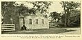
From The Diary of Captain Daniel Roe, 1806–08 (1904), caption reads: "School house near home of Capt. Daniel Roe. Near the tree, at the right, tradition says the Tory Captain Richard Miller fell from his horse in 1776."
-
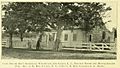
The Selden home of Daniel Roe, From The Diary of Captain Daniel Roe, 1806–1808 (1904)
See also
 In Spanish: Selden (Nueva York) para niños
