Serang facts for kids
Quick facts for kids
Serang
|
|||
|---|---|---|---|
|
City
|
|||
| City of Serang Kota Serang |
|||
| Name transcription(s) | |||
| • Sundanese | ᮞᮦᮛᮀ | ||
|
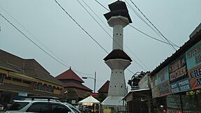
Ats-Tsauroh Great Mosque of Serang
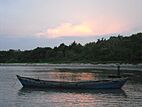
Pulau Dua Nature Reserve
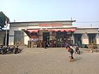
Serang Railway Station
|
|||
|
|||
| Nickname(s):
Paddy Field City
|
|||
| Motto(s):
Kota Serang Madani
(Self-reliant City of Serang) |
|||
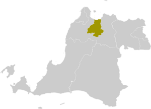
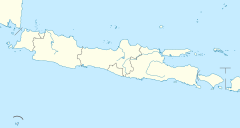
Location within Banten
|
|||
| Country | |||
| Region | Java | ||
| Province | |||
| Established | 2 November 2007 | ||
| Area | |||
| • Total | 266.18 km2 (102.77 sq mi) | ||
| Elevation | 25 m (82 ft) | ||
| Population
(mid 2023 estimate)
|
|||
| • Total | 723,794 | ||
| • Density | 2,719.19/km2 (7,042.67/sq mi) | ||
| Time zone | UTC+7 (Indonesia Western Time) | ||
| Area code | (+62) 254 | ||
| Registration plate | A | ||
Serang is a city in Indonesia and the capital of Banten province. It used to be the main city for Serang Regency, but now the capital of the Regency is Ciruas. Serang city is located in the northern part of Banten province, on the island of Java. Its northern area, called Kasemen District, has a coast facing Banten Bay. This area is home to the historic site of Old Banten, which is where the province gets its name. Before Banten province was created in 2000, Serang was part of West Java province.
Serang has a tropical rainforest climate, meaning it gets a lot of rain all year round. It faces the Java Sea, which is where the Thousand Islands are located. In mid-2023, about 723,794 people lived in Serang. This makes it one of the largest cities in Banten province. Serang is also quite close to Jabodetabek, which is the big metropolitan area around Jakarta.
Contents
Culture in Serang
Religions and Beliefs
Most people in Serang and Banten Province follow Islam. However, people of other religions also live there peacefully. Serang is sometimes called "kota santri", which means "city of pious people". This is because it has a long history as an important place for Islamic learning. The city has two large mosques: Ats-Tsauroh Great Mosque of Serang and Al-Bantani Grand Mosque. These mosques can hold many worshippers, with capacities of 2,500 and 10,000 people respectively.
Languages Spoken
While most people in Banten Province speak the Sundanese language, some residents in Serang also speak a dialect of the Javanese language. This dialect is similar to the one spoken in Cirebon. This happened because many Javanese people came to Serang in 1527 to help build the Sultanate of Banten. They stayed and became a part of the local population.
Getting Around Serang
The city has a train station called Serang station. It is run by Indonesia's national train company, PT Kereta Api Indonesia.
The Tangerang–Merak Toll Road also goes through Serang. This road is part of the larger Trans-Java toll road system, which connects many cities across Java.
City Divisions
Serang used to be part of Serang Regency. But on November 2, 2007, Serang became its own city, separate from the Regency. Now, Serang City is almost completely surrounded by Serang Regency. It borders the Regency to the south, east, and west, and the Java Sea to the north.
The City of Serang is divided into six smaller areas called districts (kecamatan). Each district has several villages, which are all considered urban areas. Here is a table showing these districts and their populations:
| Name of District (kecamatan) |
Area in km2 |
Population Estimate mid 2023 |
Number of Villages |
|---|---|---|---|
| Curug | 38.96 | 60,111 | 10 |
| Walantaka | 36.56 | 111,022 | 14 |
| Cipocok Jaya | 34.10 | 103,922 | 8 |
| Serang (district) | 26.55 | 229,739 | 12 |
| Taktakan | 61.16 | 106,874 | 13 |
| Kasemen | 68.85 | 112,126 | 10 |
| Totals | 266.18 | 723,794 | 67 |
Serang's Climate
Serang has a tropical rainforest climate. This means it gets a lot of rain throughout the year. The rain is especially heavy from December to March. The temperatures are warm and steady all year.
| Climate data for Serang | |||||||||||||
|---|---|---|---|---|---|---|---|---|---|---|---|---|---|
| Month | Jan | Feb | Mar | Apr | May | Jun | Jul | Aug | Sep | Oct | Nov | Dec | Year |
| Mean daily maximum °C (°F) | 30.4 (86.7) |
30.9 (87.6) |
31.4 (88.5) |
32.0 (89.6) |
32.3 (90.1) |
32.2 (90.0) |
32.3 (90.1) |
32.3 (90.1) |
32.8 (91.0) |
32.8 (91.0) |
32.4 (90.3) |
31.7 (89.1) |
32.0 (89.5) |
| Daily mean °C (°F) | 26.4 (79.5) |
26.9 (80.4) |
27.5 (81.5) |
27.9 (82.2) |
27.5 (81.5) |
27.1 (80.8) |
27.1 (80.8) |
27.2 (81.0) |
27.3 (81.1) |
27.9 (82.2) |
27.9 (82.2) |
27.2 (81.0) |
27.3 (81.2) |
| Mean daily minimum °C (°F) | 22.5 (72.5) |
22.6 (72.7) |
22.5 (72.5) |
22.7 (72.9) |
22.8 (73.0) |
22.1 (71.8) |
21.6 (70.9) |
21.4 (70.5) |
21.8 (71.2) |
22.3 (72.1) |
22.7 (72.9) |
22.8 (73.0) |
22.3 (72.2) |
| Average precipitation mm (inches) | 305 (12.0) |
257 (10.1) |
197 (7.8) |
154 (6.1) |
132 (5.2) |
85 (3.3) |
86 (3.4) |
82 (3.2) |
82 (3.2) |
119 (4.7) |
162 (6.4) |
217 (8.5) |
1,878 (73.9) |
Serang's Emblem
The emblem, or symbol, of Serang has a few important parts:
- It is shaped like a hexagon and shows a picture of the gerbang Kaibon, which is a famous gate. It also has a star.
- At the bottom, there is a ribbon with the city's motto: Kota Serang Madani. This means "Self-reliant Serang".
Famous People from Serang
- Arif Cahyono (born 1975) - a general in the army.
Images for kids
See also
 In Spanish: Serang para niños
 | William L. Dawson |
 | W. E. B. Du Bois |
 | Harry Belafonte |


