Setrock Creek Falls facts for kids
Quick facts for kids Setrock Creek Falls |
|
|---|---|
 |
|
| Lua error in Module:Infobox_mapframe at line 185: attempt to index field 'wikibase' (a nil value). | |
| Location | Pisgah National Forest, Yancey County, in the Blue Ridge Mountains of North Carolina |
| Coordinates | 35°44′58″N 82°13′39″W / 35.749467°N 82.227535°W |
| Type | Cascade, Slide |
| Total height | 55 ft (17 m) - disputed |
| Number of drops | 6 |
Setrock Creek Falls is a beautiful waterfall located in the Pisgah National Forest in North Carolina. It's a fun place to visit and explore nature. This waterfall is special because it's found near Mount Mitchell, which is the tallest mountain in the United States east of the Mississippi River!
Contents
Where is Setrock Creek Falls?
Setrock Creek Falls is nestled at the base of Mount Mitchell. This mountain holds the record for being the highest peak east of the Mississippi River. The water for the falls comes from Setrock Creek. This creek is a small stream, also known as a tributary, that flows into the South Toe River. The South Toe River then joins the Nolichucky River.
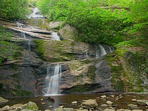
The waterfall flows over several rocky sections. These rocks can be very steep! A thick canopy of trees covers the area, making it feel like a hidden gem. During dry weather, the water flow can slow down quite a bit. The water gently clings to the rocks as it falls, ending in a nice pool at the bottom.
How Tall is the Waterfall?
There's a bit of a friendly debate about the exact height of Setrock Creek Falls. Some people say it's about 55 feet (17 meters) tall. This measurement comes from a book called "North Carolina Waterfalls" by Kevin Adams. However, another source, the North Carolina Waterfalls website, suggests the falls might be taller, around 75 feet (23 meters) high. No matter the exact height, it's still an impressive sight!
Visiting Setrock Creek Falls
If you want to visit Setrock Creek Falls, here's how you can get there:
- Start at the intersection of NC 80 and the Blue Ridge Parkway.
- Drive north on NC 80 for about 2.2 miles.
- Turn left onto South Toe River Road.
- You'll pass the turn-off for Roaring Fork Falls. Keep going for about 2.19 miles until you reach a fork in the road.
- At the fork, turn right and drive another 0.61 miles to the Black Mountain Campground.
- Once you're at the campground, find the hiker parking area.
- Enter the campground and take the road furthest to your left, which is Briar Bottom Road.
- After about 200 yards from the parking area, this road crosses a small creek.
- Take the trail on your left. You'll pass the start of the Mount Mitchell Trail.
- Cross Little Mountain Creek.
- Take the path to your right and walk about 200 yards. You'll soon reach the beautiful Setrock Creek Falls!
Other Waterfalls Nearby
The area around Setrock Creek Falls is full of other amazing waterfalls you might want to explore. Some of these include:
 | Aaron Henry |
 | T. R. M. Howard |
 | Jesse Jackson |

