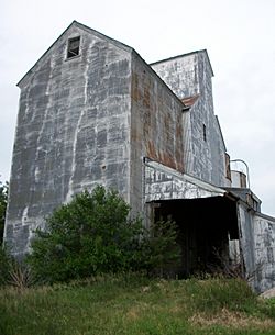
Sexton, Iowa facts for kids
Quick facts for kids
Sexton, Iowa
|
|
|---|---|

Sexton elevator
|
|
| Country | |
| State | |
| County | Kossuth |
| Townships | Irvington, Prairie |
| Post office opened | August 20, 1888 |
| Area | |
| • Total | 2.20 sq mi (5.70 km2) |
| • Land | 2.20 sq mi (5.70 km2) |
| • Water | 0.00 sq mi (0.00 km2) |
| Elevation | 1,220 ft (370 m) |
| Population
(2020)
|
|
| • Total | 46 |
| • Density | 20.89/sq mi (8.07/km2) |
| Time zone | UTC-6 (Central (CST)) |
| • Summer (DST) | UTC-5 (CDT) |
| ZIP Code |
50483
|
| Area code(s) | 515 |
| GNIS feature ID | 461516 |
| FIPS code | 19-71715 |
Sexton is a small community in Kossuth County, Iowa, United States. It's not a city or town with its own government, but it's recognized as a census-designated place (CDP). This means the U.S. Census Bureau collects information about the people living there. Sexton is located where two roads meet: U.S. Route 18 and Kossuth CR P60. In 2020, 46 people lived in Sexton.
A Look Back at Sexton
Sexton was officially planned and marked out on a map in 1889. This process is called "platting." Back in 1902, the community had 42 residents.
A post office was open in Sexton for many years, from August 1888 until May 1974. Today, you can still find a few houses, a place called Racer's Bar and Grill, and the large Sexton elevator, which is a building used to store grain.
Where is Sexton?
Sexton is located in the southeastern part of Kossuth County in Iowa. It's about 8 miles (13 km) east of Algona, Iowa, which is the main town and county seat. It's also about 5 miles (8 km) west of Wesley, Iowa.
The area of Sexton, as defined by the U.S. Census Bureau, covers about 2.2 square miles (5.7 square kilometers). All of this area is land. The community sits on the south side of U.S. Route 18.
Who Lives in Sexton?
| Historical population | |||
|---|---|---|---|
| Census | Pop. | %± | |
| 2010 | 37 | — | |
| 2020 | 46 | 24.3% | |
| U.S. Decennial Census | |||
According to the census taken in 2020, there were 46 people living in Sexton. These people lived in 19 different households, and 12 of those households were families.
Most of the people living in Sexton were White (91.3%). A small number were Black or African American (4.3%) or Asian (4.3%). No one identified as Hispanic or Latino in the 2020 census.
The average age of people in Sexton was 28.5 years old. About 21.7% of the residents were under 20 years old. The community had an equal number of males and females, with 50% male and 50% female residents.
See also
 In Spanish: Sexton (Iowa) para niños
 | Emma Amos |
 | Edward Mitchell Bannister |
 | Larry D. Alexander |
 | Ernie Barnes |


