Sgurr Mhurlagain facts for kids
Quick facts for kids Sgurr Mhurlagain |
|
|---|---|

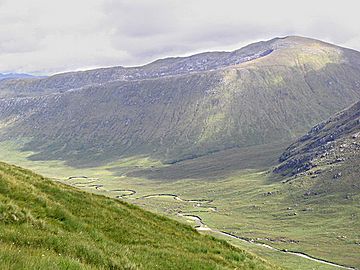
Sgurr Mhurlagain with Glen Kingie in the foreground
|
|
| Highest point | |
| Elevation | 880 m (2,890 ft) |
| Prominence | 515 m (1,690 ft) |
| Listing | Corbett, Marilyn |
| Geography | |
| Location | Lochaber, Scotland |
| Parent range | Northwest Highlands |
| OS grid | NN012944 |
| Topo map | OS Landranger 33 |
Sgurr Mhurlagain is a mountain in the beautiful Northwest Highlands of Scotland. It stands tall at 880 meters (about 2,887 feet) above sea level. This impressive peak is located west of a small village called Spean Bridge in an area known as Lochaber.
About Sgurr Mhurlagain
Sgurr Mhurlagain is a large and strong-looking mountain. It forms a big part of the southern side of Glen Kingie, which is a long valley. To its south, you'll find Loch Arkaig, a large and peaceful lake. From the top of Sgurr Mhurlagain, three different ridges stretch out towards the northeast. These ridges are like natural pathways leading down from the summit.
Where is Sgurr Mhurlagain Located?
This mountain is found in the Northwest Highlands, a stunning part of Scotland known for its rugged landscapes and wild beauty. It's part of the wider Lochaber region, which is sometimes called the "Outdoor Capital of the UK" because of all the exciting activities you can do there. The mountain's exact spot can be found using a special map reference: NN012944.
What Kind of Mountain is Sgurr Mhurlagain?
Sgurr Mhurlagain is special because it's listed as both a Corbett and a Marilyn.
- A Corbett is a mountain in Scotland that is between 762 meters (2,500 feet) and 914.4 meters (3,000 feet) tall. There are many Corbetts across Scotland, and climbing them is a popular hobby.
- A Marilyn is a hill or mountain of any height that has a "prominence" of at least 150 meters (about 492 feet). Prominence means how much a mountain rises above the lowest point connecting it to a higher peak. Sgurr Mhurlagain has a prominence of 515 meters, which makes it a very noticeable peak in the landscape.
 | Chris Smalls |
 | Fred Hampton |
 | Ralph Abernathy |

