
Waterfall Country (Wales) facts for kids
Waterfall Country is a special area in South Wales, often called the Vale of Neath. It's famous for having many beautiful waterfalls that people can visit. This area isn't officially marked on a map, but it usually includes waterfalls on the Nedd Fechan, Pyrddin, Hepste, and Mellte rivers. These rivers are all found between the villages of Pontneddfechan and Ystradfellte, inside the amazing Brecon Beacons National Park.
All these waterfalls are in the old county of Brecknockshire, which is now part of Powys. A bit further west, you'll find Henrhyd Falls on the Nant Llech, which flows into the River Tawe. To the southwest are Melin Court Falls on the Melin Court Brook, a small river that joins the River Neath. Some people also include Aberdulais Falls on the River Dulais, another river that flows into the Neath, when they talk about 'Waterfall Country'.
These waterfalls are very popular natural attractions in South Wales. Because so many people visit, there have been some problems with the ground wearing away near the falls. Most of these places are protected as special scientific sites or special conservation areas. This helps protect the amazing plants, animals, and rocks found there. Landowners and managers work to protect these sites, and they've put in place ways to stop the worst of the erosion.
Contents
How the Waterfalls Formed
Almost all the waterfalls here are on smaller rivers that flow into the River Neath. These rivers have carved deep valleys into the land. Scientists believe that during the ice ages, huge glaciers made the main Vale of Neath valley much deeper. This caused the smaller rivers to cut down into their own beds, creating the waterfalls we see today.
The rocks under the ground here are mostly sandstones and mudstones from a time called the Carboniferous period. The softer mudstones wear away more easily than the harder sandstones. This means the sandstones are left sticking out, forming the edges or "lips" of the waterfalls. Many waterfalls are also found where there are faults in the rock. These are cracks where different types of rock meet, which can also help create a waterfall.
The Falls
On the Afon Mellte
There are three main waterfalls on the Afon Mellte, plus a few smaller ones.


- Sgwd Clun-gwyn - This means 'fall of the white meadow'. It's the highest of the three main falls on the Mellte. It formed where a crack in the earth's crust, called a fault, pushed hard sandstone against softer mudstone.
- Sgwd Isaf Clun-gwyn - This is the 'lower fall of the white meadow' and is the middle of the three falls.
- Sgwd y Pannwr - This fall is called the 'fall of the fuller' or 'fall of the woollen washer'. It's the lowest of the three famous falls on the Mellte.
On the Afon Hepste

Sgwd yr Eira - This waterfall is super famous because you can actually walk behind it! Its name means 'falls of snow'. The water plunges over a hard band of sandstone that sticks out, creating a natural shelter for walkers. For a while in 2007 and 2008, the path behind the falls was closed for safety. But after some work by the Forestry Commission, Countryside Council for Wales, and the Brecon Beacons National Park Authority, it was reopened. If you want to see Sgwd Clun-gwyn, Sgwd Isaf Clun-gwyn, and Sgwd yr Eira, look for the 'Waterfall Walk' near Ystradfellte.
On the Nedd Fechan
There are three waterfalls on this river that visitors especially like, along with other smaller ones.
- Sgwd Ddwli Uchaf - These are the 'upper gushing falls'.
- Sgwd Ddwli Isaf - These are the 'lower gushing falls'.
- Sgwd y Bedol - These are called the 'horseshoe falls'. They are actually a group of three or four waterfalls close together.
On the Afon Pyrddin
- Sgwd Gwladus - Also spelled Sgwd Gwladys, this waterfall is where the Afon Pyrddin drops about 6 meters over a rock edge. The Welsh name was changed to Lady's Falls a long time ago, but Gwladus is a real name, belonging to one of the daughters of Brychan, a king from the 5th century. The rock here slopes gently, pushing the water against a tall cliff and over the left side of the rock lip. When there's more water, the fall spreads out further to the right. The top of the rock has cool patterns from old fossil tree roots.
- Sgwd Einion Gam - This waterfall is linked to the legend of the 'lady' of Sgwd Gwladus. Its name means 'fall of crooked Einion'. It's one of the most amazing, but also hardest to reach, waterfalls in the area. The river drops about 21 meters into a deep pool surrounded by dark cliffs covered in moss. This fall was created where the Pyrddin river drops off a fault line in a hard sandstone rock called the Farewell Rock. Getting to it is tricky, with only a rough path and several river crossings needed from Sgwd Gwladus.
On Other Rivers
- Sychryd Cascade - Here, the waters of Sychryd flow between the rocky walls of Craig-y-Ddinas (Dinas Rock) and Bwa Maen (Stone Bow). It's not one single waterfall, but the river tumbles over many rocks in this spot. This rocky channel was carved by the river along a major crack in the earth called the Neath Disturbance. There used to be a metal ramp over the cascades, but it's gone now. You can see more falls further up the river from the north bank, which is open to the public.
- Henrhyd Fall
The Nant Llech river starts on the slopes of Carreg Cadno and flows to the village of Coelbren. Here, it drops about 27 meters over a cracked section of the hard Farewell Rock. This spectacular waterfall and the gorge below it are looked after by the National Trust. In Welsh, it's called Sgwd Henryd or Rhaeadr Henryd.
- Aberdulais Falls
The Dulais river starts near the town of Aberdulais/Seven Sisters. It flows for several miles to join the River Neath at Aberdulais. The falls are only about 150 meters upstream from where the rivers meet. You can easily get to them from the A465 road. This isn't just a beautiful waterfall; it's also an important place for industrial heritage, now cared for by the National Trust.
- Melincourt Falls
Melin Court Brook starts high up southeast of Resolven in the Vale of Neath. It drops from about 450 meters above sea level to about 30 meters in less than 5 kilometers. There are several falls along its path, but the single big drop of about 24 meters at Melincourt is the most impressive. People have been visiting it for over 200 years, ever since the famous painter Turner painted it in 1794.
You can see the falls (also known as Melincwrt Falls) from above, where a small road crosses the brook just upstream. You can also see them from below by following a footpath that goes up beside the brook from the B4334 road between Melincourt village and Resolven.
The falls are part of a 13-acre nature reserve managed by the Wildlife Trust of South and West Wales. Neath Port Talbot County Borough Council provides parking near the start of the path to the falls.
Images for kids
-
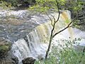
Sgwd Clun-gwyn (Upper White Meadow Fall)
-
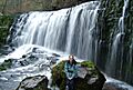
Sgwd Isaf Clun-gwyn (Lower White Meadow Fall)
-
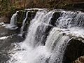
Sgwd y Pannwr (Fuller's Fall)
-
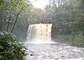
Sgwd yr Eira in full flow
