Sgùrr nan Eugallt facts for kids
Quick facts for kids Sgùrr nan Eugallt |
|
|---|---|

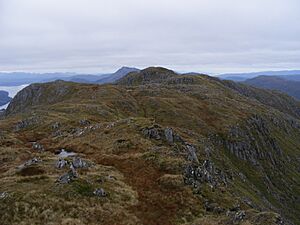
The summit ridge of Sgùrr nan Eugallt, seen from the ridge above the top of the stalkers' path to the north east
|
|
| Highest point | |
| Elevation | 898 m (2,946 ft) |
| Prominence | 623 m (2,044 ft) Ranked 100th in British Isles |
| Parent peak | Ladhar Bheinn |
| Listing | Corbett, Marilyn |
| Naming | |
| English translation | Peak of the death streams |
| Language of name | Scottish Gaelic |
| Geography | |
| Location | Loch Hourn, Highland, Scotland |
| Parent range | Northwest Highlands |
| OS grid | NG926049 |
| Topo map | OS Landranger 33 |
Sgùrr nan Eugallt is a mountain in the beautiful Northwest Highlands of Scotland. Its name comes from Scottish Gaelic and means "Peak of the death streams." It stands tall south of Loch Hourn, part of a group of mountains stretching from Barrisdale to Loch Quoich.
Even though Sgùrr nan Eugallt isn't as high as some of its neighbors, it's special because deep valleys completely surround it. This makes it feel very separate and remote. It's a "Corbett" mountain, which means it's over 2,500 feet (762 meters) high, but not quite tall enough to be a "Munro" (a mountain over 3,000 feet or 914 meters). Because it's so isolated and not a Munro, fewer people climb Sgùrr nan Eugallt.
How to Climb Sgùrr nan Eugallt

Climbing Sgùrr nan Eugallt can be an exciting adventure! You can start your journey from a ruined cottage located about 4 kilometers (2.5 miles) east of the mountain's top. There's a small parking area there, but remember the road leading to it is narrow and single-track. It's also about 20 miles (32 kilometers) from the nearest main road, so it's quite a remote spot.
Following the Old Stalkers' Path
An old path, once used by deer stalkers, helps guide climbers up the mountain. This path leads you to a spot just below a ridge, at an elevation of about 650 meters (2,130 feet). While the path was well-built a long time ago, some parts can now be wet and slippery, so be careful!
Reaching the Summit
Once you reach the ridge, turn left and follow it towards the top. You'll come to a triangulation point at 894 meters (2,933 feet). The ridge gets steep as you get closer to the top, but there are ways to go around the steepest parts.
It's important to know that the true highest point of Sgùrr nan Eugallt isn't actually at this triangulation point. The real summit is about 600 meters (about 0.4 miles) to the northwest. So, if you want to reach the very top, turn right along the main ridge from the triangulation point and continue for about 600 meters. This main summit isn't even marked on most maps! About 300 meters (0.2 miles) further along the ridge, you'll find another 881-meter (2,890-foot) summit, which is shown on maps.
 | DeHart Hubbard |
 | Wilma Rudolph |
 | Jesse Owens |
 | Jackie Joyner-Kersee |
 | Major Taylor |

