Beinn Sgritheall facts for kids
Quick facts for kids Beinn Sgritheall |
|
|---|---|

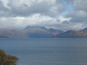
Beinn Sgritheall seen from the Sleat peninsula, Skye
|
|
| Highest point | |
| Elevation | 974 m (3,196 ft) |
| Prominence | 500 m (1,600 ft) |
| Parent peak | Sgurr a' Mhaoraich |
| Listing | Munro, Marilyn |
| Naming | |
| English translation | scree hill |
| Language of name | Gaelic |
| Pronunciation | English approximation: ben-SKREE-həl |
| Geography | |
| Location | Knoydart, Scotland |
| OS grid | NG836126 |
| Topo map | OS Landranger 33 |
Beinn Sgritheall (pronounced ben SKREE-həl) is a tall and beautiful mountain in the Highlands of Scotland. It's the highest peak in the Glenelg area. Many people start their climb from Arnisdale, a village by Loch Hourn. Another way is through Gleann Beag, known for its ancient stone towers called brochs. Sir Hugh Munro, who helped start the Scottish Mountaineering Club, once said the view from its top was "perhaps the most beautiful I have seen in Scotland."
Contents
What is Beinn Sgritheall?
Beinn Sgritheall is a famous mountain in Scotland. Its name comes from the Gaelic words for "scree hill." This means it has a lot of loose rocks on its slopes. It stands tall in the Knoydart region of the Scottish Highlands.
How Mountains are Classified in Scotland
Mountains in Scotland are grouped by their height. Beinn Sgritheall is special because it fits into two important categories:
- Munro: This is a Scottish mountain that is over 3,000 feet (914 meters) tall. Beinn Sgritheall is 3,196 feet (974 meters) high, making it a Munro.
- Marilyn: This is a hill or mountain with a "prominence" of at least 500 feet (150 meters). Prominence means how much a mountain rises above the land around it. Beinn Sgritheall has a prominence of 1,640 feet (500 meters).
Beinn Sgritheall is the highest mountain on the Glenelg peninsula. This area is mostly wild and empty. It is surrounded by Loch Alsh and Loch Duich to the north. Loch Hourn is to its west and south.
Exploring Beinn Sgritheall's Features
Beinn Sgritheall has a narrow, curved top that runs next to the north shore of Loch Hourn. Several ridges stretch out from this main crest. The south side of the mountain rises almost 3,300 feet (1,000 meters) from Loch Hourn to its top. This happens over just one mile (1.6 kilometers).
Mountain Tops and Ridges
Beinn Sgritheall has three main high points:
- The main summit is 3,196 feet (974 meters) high.
- There's also a Middle Top, which is also 3,196 feet (974 meters).
- An East Top is a bit lower at 2,972 feet (906 meters).
The western side of the mountain has steep cliffs and loose rock. The northern and eastern parts have several remote, bowl-shaped valleys called corries. Two ridges go northeast from the summit. One of these curves northwest, forming a high corrie. A third ridge goes west to Creag an Taghain, which is a rocky cliff above the Coille Mhialairigh forest.
Amazing Views from the Summit
The view from the top of Beinn Sgritheall is truly amazing. You can see many islands like Jura, Rùm, and Mull. You can also spot other mountain ranges like Knoydart, Skye, and Moidart. Even famous peaks like Ben Nevis and Slioch are visible. The long ridges of Glen Affric and Glen Shiel can also be seen.
It's possible to see over 100 named peaks from this summit. A famous hiker named Hamish Brown once said he wouldn't trade the view from Beinn Sgritheall "for any mountain view in the world." The rocks that make up Beinn Sgritheall are a type called schistose.
How to Climb Beinn Sgritheall
Most people start their climb of Beinn Sgritheall from the village of Arnisdale. This village is right on the shores of Loch Hourn. Another way to start is from Gleann Beag to the north. This area is famous for its ancient stone towers called brochs.
Both of these starting points are a bit remote. You can only reach them by driving on a single-lane road from Glen Shiel. Or, you can take a ferry or boat across the waters of Loch Hourn.
Popular Climbing Routes
Hikers often complete different routes to reach the summit. One common way is to start from the southwest side of the mountain. You then climb up the west ridge through the Coille Mhialairigh forest. After reaching the summit, you can continue along the southeast ridge. This path leads to the Bealach Arnasdail pass. From there, you can walk down to Loch Hourn, which is about 5 miles (8 kilometers) from where you started.
 | John T. Biggers |
 | Thomas Blackshear |
 | Mark Bradford |
 | Beverly Buchanan |


