Shadowood, Oregon facts for kids
Quick facts for kids
Shadowood, Oregon
|
|
|---|---|

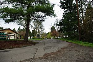
Street in the community
|
|
| Country | United States |
| State | Oregon |
| County | Clackamas |
| Elevation | 190 ft (60 m) |
| Time zone | UTC-8 (Pacific (PST)) |
| • Summer (DST) | UTC-7 (PDT) |
| ZIP code |
97068
|
| GNIS feature ID | 1136738 |
Shadowood is a small place in Clackamas County, Oregon, United States. It's called an unincorporated community. This means it's a neighborhood that doesn't have its own local government like a city does. Instead, it's managed by the county.
Shadowood is located about four miles south of Lake Oswego. You can find it near the Tualatin River, just east of Shipley Bridge. Even though it's in Clackamas County, it uses a West Linn ZIP code.
Contents
Exploring Shadowood's Neighborhood
Shadowood is a rural neighborhood, meaning it has a countryside feel. About 64 homes are located here. These homes are built on both sides of a natural dip in the land called a ravine. A small, unnamed creek flows through this ravine.
Wetlands and Water System
The ravine area also has wetlands. Wetlands are areas where water covers the soil, or is present near the surface, for all or parts of the year. They are important for nature.
The homes in Shadowood get their water from a special system. This water system was first built in 1922 and started providing water in 1924.
The History of Shadow Wood Park
The area we now call Shadowood was originally known as Shadow Wood Park. It started in the 1920s as a place for people to have "recreational retreats." This means people built small homes there to relax and enjoy nature, like vacation homes.
Original Homes and Style
The very first homes built in Shadow Wood Park were log houses. They were designed in a style called American Craftsman/Rustic. This style uses natural materials like wood and stone. It often features simple, strong designs that blend in with the outdoors.
 | Sharif Bey |
 | Hale Woodruff |
 | Richmond Barthé |
 | Purvis Young |


