
Shannopin's Town facts for kids
Quick facts for kids
Shannopin's Town
|
|
|---|---|
|
Historic Native American village
|
|

Shannopin's Town
Location in Pennsylvania

Shannopin's Town
Location in the United States
|
|
| State | Pennsylvania |
| Present-day Community | Lawrenceville (Pittsburgh) |
| Founded | before 1730 |
| Abandoned | 1759 |
| Population | |
| • Estimate
(1750)
|
100-200 |

Shannopin's Town was an old Lenape (Delaware) village from the 1700s. It was located where Pittsburgh, Pennsylvania is today, near the Allegheny River. This was about two miles east of where the Allegheny and Monongahela Rivers meet.
In the early 1700s, British settlers started moving into western Pennsylvania. This caused the Lenape and other Native American tribes to move further west. They settled in an area called the Ohio Country. Shannopin's Town was one of these new communities built in the 1720s.
Most of the town was left empty when Fort Duquesne was built in 1754. A small group of people still lived there when General John Forbes' soldiers arrived in 1758. By the time Fort Pitt was started in 1759, the village was completely gone.
Contents
Where Was Shannopin's Town Located?
The village is thought to have been settled by 1730. We know its location from old journals, maps, and a burial site found in 1862.
The town was in what is now the Lawrenceville neighborhood of Pittsburgh. It was on the south bank of the Allegheny River, across from Herr's Island. This spot was important because a trail from Harrisburg, Pennsylvania, crossed the Allegheny River here.
Shannopin's Town was also at the end of two important Native American trails: the Kittanning Path and the Venango Path. It was a good place to cross the river. It was also close to other important trading communities like Logstown and Kittanning.
Who Was Chief Shannopin?
Not much is known about Chief Shannopin, who likely founded the town. His name was also spelled "Shawanoppan" or "Shawanosson."
In 1730, Shannopin and five other Lenape leaders sent a letter to the Governor. They complained about too much rum being sold in their communities. They asked the Governor to control the traders and stop them from bringing so much alcohol.
Shannopin died sometime between 1748 and 1751.
Important Visitors to the Town
Shannopin's Town was a busy place. Many important people visited it during the 1700s.
Peter Chartier's Visit (1743-1745)
In 1743, Peter Chartier, a trader who was half Shawnee, moved to Shannopin's Town. He set up a trading post nearby. Chartier disagreed with Pennsylvania leaders because he did not want alcohol sold to Native Americans. In 1745, he sided with the French and moved away.
Conrad Weiser's Visit (1748)
Conrad Weiser stayed at Shannopin's Town on August 26, 1748. He was on his way to Logstown for a meeting with different Native American chiefs. Benjamin Franklin's son, William Franklin, who was 19, traveled with Weiser. This trip made Benjamin Franklin very interested in the frontier.
Céloron de Blainville's Visit (1749)
In 1749, the French wanted to show their power over the Ohio Country. So, Pierre Joseph Céloron de Blainville led a large group of soldiers and Native Americans down the Ohio River. This was called his "lead plate expedition." They buried lead plates and nailed copper plates to trees to claim the land for New France.
Céloron reached Shannopin's Town on August 7, 1749. He saw only three men there, with a white flag. Most of the villagers had left for Logstown.
Christopher Gist's Visit (1750)
Christopher Gist first visited Shannopin's Town in November 1750. It was a small town with about twenty wigwams. There were around fifty or sixty Native Americans, including twenty warriors. Many traders visited the town.
Gist wrote that he stayed in the town for a few days because he was sick. He secretly measured the Ohio River, finding it to be about 76 poles wide (about 1250 feet). He noted that the land around the river was good for farming.
Virginia Commissioners' Meeting (1752)
In May 1752, officials from Virginia stopped at Shannopin's Town. They met with Lenape chiefs Shingas and Tamaqua. The officials gave them coats and hats, and noted that the chiefs wore silver breastplates and Wampum. The officials were on their way to a meeting at Logstown to improve relations with the Ohio Native Americans.
George Washington's Visit (1753)
George Washington and Christopher Gist met with Chief Shingas at Shannopin's Town on November 23, 1753. They were on their way to speak with the French commander at Fort Le Boeuf.
Later, on his way back from his mission, Washington almost drowned near Shannopin's Town. On December 29, 1753, he and Gist tried to cross the icy Allegheny River on a raft. The raft hit ice, and Washington fell into the freezing water. He managed to grab the raft, and Gist pulled him out. They spent the night on a nearby island before continuing their journey.
French Military Arrives (1754)
In January 1754, British soldiers started building Fort Prince George near where the Ohio and Monongahela rivers meet. This was about two miles west of Shannopin's Town.
In April 1754, a large French force arrived at Shannopin's Town. They sailed down the Allegheny River. On April 18, the French commander told the British to leave their fort within an hour. The British soldiers, about forty of them, left. The French then took over the fort and tore it down to build Fort Duquesne.
Why Was the Town Abandoned?
Shannopin's Town was mostly abandoned when Fort Duquesne was being built. A British prisoner saw a small community there in 1756. However, by the time Fort Pitt was started in 1759, the town was completely gone.
What Have We Learned from Archaeology?
Archaeologists have found little from the 1700s in the Pittsburgh area. This is because a lot of building and industry has disturbed the old sites. A Native American burial site was found in 1862 during construction, but not much else was recorded.
However, some work near Fort Pitt has found old features. These include fire pits, trash areas, and parts of old walls. They have also found old pottery, glass beads, and metal items.
Images for kids
-
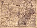
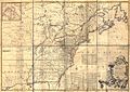
Lewis Evans' General Map of the Middle British Colonies in America, showing "Shanoppins T." near Fort Duquesne.
-
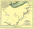
Map of the route followed by Pierre Joseph Céloron de Blainville along the Ohio River in 1749.
-
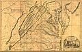
1751 map by Joshua Fry and Peter Jefferson depicting "Shannopin's T."
-
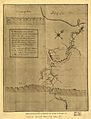
George Washington's 1754 map showing "Shanapin" at the confluence of the Ohio and the Monongahela rivers.
-
1755 map by John Mitchell showing "Shanapins" just north of Fort Duquesne.
-
Map of the route General Forbes' forces took to reach Fort Duquesne in September, 1758.
-
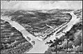
Newly-constructed Fort Pitt in 1759. The abandoned remains of Shannopin's Town can be seen on the riverbank to the far left.


