Shawangunk, New York facts for kids
Quick facts for kids
Shawangunk
|
|
|---|---|

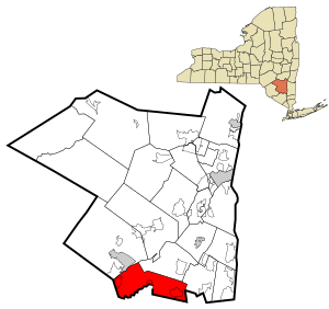
Location in Ulster County and the state of New York.
|
|
| Country | United States |
| State | New York |
| County | Ulster |
| Area | |
| • Total | 56.55 sq mi (146.46 km2) |
| • Land | 56.06 sq mi (145.18 km2) |
| • Water | 0.49 sq mi (1.28 km2) |
| Elevation | 335 ft (102 m) |
| Population
(2020)
|
|
| • Total | 13,563 |
| • Density | 239.841/sq mi (92.605/km2) |
| Time zone | UTC-5 (Eastern (EST)) |
| • Summer (DST) | UTC-4 (EDT) |
| FIPS code | 36-66674 |
| GNIS feature ID | 0979486 |

Shawangunk is a town located in the southwestern part of Ulster County, New York, in the United States. In 2020, about 13,563 people lived here. The town gets its name from its biggest stream, the Shawangunk Kill. The name "Shawangunk" comes from the language of the Lenape people. "Kill" is a short form of the Dutch word Killitje, which means creek. You say it like Shuh-Whan-Gung /ˈʃɑːwəŋɡʌŋk/.
Contents
Discovering Shawangunk's Past
Early European Settlements
Europeans first settled in Shawangunk in the 1680s. The area was first called a "precinct" around 1710. It officially became the Township of Shawangunk in 1788.
What Does the Name Mean?
The town's name comes from a Lenape word or phrase. It was probably pronounced "Sha-WAN-gunk." This likely meant "in the smoky air." The name first appeared in a land deed in 1682. This deed was for land bought by Gertrude Bruyn from the Lenape people.
It's not fully clear if this was the actual name for a nearby village. That village was destroyed by the Dutch in 1663. This happened during the Second Esopus War. The name might have just been a phrase used for the land sale. It could have described something about the landscape at that time. For example, it might have referred to smoky conditions. This could have been from a fire or the ruins of the destroyed village. Later, the name was used for the Shawangunk Kill creek and the mountain range.
How Locals Say It
Today, many locals say the name "SHONG-gum." This is a shorter version of the original name. People living in Shawangunk often say they live in smaller areas. These include places like Wallkill or Walker Valley. This is because many residents in the western part of town go to school in Pine Bush. They also have Pine Bush mailing addresses. They often shop in Pine Bush, which is in Orange County.
Geography of Shawangunk
Land and Water Areas
The town of Shawangunk covers about 56.5 square miles (146.46 square kilometers). Most of this area is land, about 56.2 square miles (145.18 square kilometers). A small part, about 0.3 square miles (1.28 square kilometers), is water.
Borders and Rivers
The southern border of the town is shared with Orange County. Part of the eastern border also touches Orange County. The Wallkill River flows through the eastern part of the town. The hamlet of Wallkill is named after this river. It sits on the river's east bank.
The western part of Shawangunk includes Walker Valley. This area climbs the lower slopes of the Shawangunk Mountains. The Shawangunk Kill is a major stream that flows into the Wallkill River. It divides the town almost in half.
Population of Shawangunk
How Many People Live Here?
As of 2009, about 12,652 people lived in Shawangunk. There were 4,333 households. A household is a group of people living together. About 2,557 of these were families. The population density was about 225 people per square mile. This means 225 people lived in each square mile of land.
Who Lives in Shawangunk?
Most people in the town were White (83%). About 7.9% were African American. Other groups included Native American, Asian, and Pacific Islander people. About 6.96% of the population was Hispanic or Latino.
Families and Age Groups
About 39.2% of households had children under 18 living with them. Most households (61.5%) were married couples. About 20.2% of all households were single individuals. The average household had 2.78 people. The average family had 3.21 people.
The population had a mix of ages. About 22.4% were under 18. About 38.3% were between 25 and 44 years old. The average age in the town was 36 years.
Income and Poverty
The average income for a household in the town was about $52,366. For families, it was about $59,975. About 4.4% of families lived below the poverty line. This means they had very low incomes. About 13.4% of the total population was below the poverty line.
Geology of Shawangunk
The Mighty Mountains
The Shawangunk Mountains rise 2,000 feet above the town. These mountains are mostly made of quartz. They were formed over 10,000 years ago. This happened during the last ice age. Huge glaciers carved them out. They are part of the larger Catskill Mountains. These mountains attract tourists and climbing fans from all over the world.
Communities and Places in Shawangunk
- Awosting – A small community in the northwestern part of the town.
- Bruynswick – A community near the northern town line.
- Crawford – A community in the northwestern part of the town.
- Dwaarkill – A community north of Red Mills.
- Galeville – A former community in the eastern part of the town. It is north of Wallkill. Galeville is on the west bank of the Wallkill River. It was once home to Galeville Army Air Base. Now it is the Shawangunk Grasslands National Wildlife Refuge.
- New Hurley – A former community.
- Red Mills – A community at the southern town line. It is north of Pine Bush.
- Rutsonville – Another community in the town.
- Shawangunk Kill – A small stream that flows through the town.
- Ulsterville – A community east of Pine Bush.
- Watchtower – This area is made up of the residents of Watchtower Farms. This is a printing facility run by the Watchtower Society (Jehovah's Witnesses). It has been operating since 1963.
- Walker Valley – A community in the southwest part of the town. It is west of Pine Bush.
- Wallkill – A community at the eastern town line.
- Shawangunk Correctional Facility – A New York state prison north of Wallkill.
- Wallkill Correctional Facility – Another state prison north of Wallkill.
See also
 In Spanish: Shawangunk para niños
 | Chris Smalls |
 | Fred Hampton |
 | Ralph Abernathy |

