
Shawangunk Kill facts for kids
Quick facts for kids Shawangunk Kill |
|
|---|---|

|
|
| Country | United States |
| State | New York |
| Region | Hudson Valley |
| Counties | Orange, Sullivan, Ulster |
| Towns | Greenville, Mamakating, Wawayanda, Wallkill, Crawford, Shawangunk, Gardiner |
| Physical characteristics | |
| Main source | Unnamed pond Greenville, New York 1,240 ft (380 m) 41°23′35″N 74°36′10″W / 41.3931°N 74.6029°W |
| River mouth | Wallkill River W of Gardiner, New York 180 ft (55 m) 41°41′01″N 74°09′55″W / 41.6835°N 74.1652°W |
| Length | 47 mi (76 km) |
| Basin features | |
| Basin size | 147 sq mi (380 km2) |
The Shawangunk Kill is a stream about 47 miles (76 kilometers) long. It flows north through three counties in New York State: Orange, Sullivan, and Ulster. It is the biggest stream that flows into the Wallkill River.
The stream gets its name from the nearby Shawangunk Ridge. It starts high up in the town of Greenville. Then it flows down into the valley. For some of its journey, it forms the border of Orange County. Sullivan County and then Ulster County are on the other side of the stream.
Contents
The Shawangunk Kill's Journey
The Shawangunk Kill begins its journey in Greenville. It flows steadily northeast towards Mill Pond, near Mount Hope. By this point, it has already dropped almost half of its starting height. The stream passes through open fields and thick woods. These areas are east of Otisville.
At a small community called New Vernon, the stream becomes the border between Orange and Sullivan counties. Soon after, it meets its first named smaller stream, the Little Shawangunk Kill.
The Shawangunk Kill starts to get wider near Bloomingburg. North of this town, the busiest road along the stream, NY 17, crosses over it. A few miles further north, another stream called the Platte Kill joins it. This is where Orange, Sullivan, and Ulster counties all meet. The stream then turns slightly more towards the east.
The town of Pine Bush appears to the east. A few more miles north of Pine Bush, the stream flows entirely within Ulster County. This happens when the county border moves away from the stream. The Shawangunk Kill continues to wind through a wider valley. This valley is mostly filled with farms and woodlots (small forests). The mountain ridge stretches across the western sky. Finally, the stream turns directly east and joins the Wallkill River. This meeting point is just south of US 44 and NY 55, near Gardiner.

Amazing Plants and Animals of the Shawangunk Kill
In the early 1990s, the U.S. Fish and Wildlife Service studied the lower part of the Shawangunk Kill. This area stretches from its mouth up to Pine Bush. They found that this part of the stream has a very special and diverse community of plants and animals. This is because there are no big dams blocking the river upstream.
The study found at least six types of freshwater mussels living there. This included a rare one called the swollen wedge mussel. They also found 31 different kinds of fish! Some of these fish are quite rare. These include the Notropis amoenus (comely shiner), Notropis stramineus (sand shiner), Percina caproedes (logperch), Lepomis auritis (redbreasted sunfish), and Noturus insignis (margined madtom).
The study also discovered that this region is the only known place in New York State where a plant called Diarrhena obovata (beakgrass) grows. Other rare plants found in the lower Shawangunk Kill include threadfoot on underwater rocks. Sharp-winged monkeyflower, wingstem, and redrooted flatsedge grow right along the stream. In the flood plains, you can find Davis' sedge, swamp agrimony, Aster vimeneus (small white aster), and violet bushclover, along with the beakgrass.
Protecting the Shawangunk Kill
Most of the land around the Shawangunk Kill has very little development. It is mostly used for farming. This means there is very little pollution in the stream. In 2015, the town council members of Wallkill passed a law to help protect the Shawangunk Kill. About 5 miles (8 kilometers) of the stream flow through Wallkill.
This law stops any new construction, including roads, near the stream. It also bans clear cutting trees, dumping trash, or building septic systems within 100 feet (30 meters) of the stream's high water mark. The town of Crawford, which is north of Wallkill, also has rules in place. These rules limit new buildings and rebuilding near the stream. In Mount Hope, much of the land around the stream is owned by the town. This helps keep it protected.
How the Shawangunk Valley Formed
The rocks under the river are mostly shale. This shale is covered by silty loam soils. These soils were left behind by glaciers long ago. The stream bed itself changes. It can be solid rock in some places. In others, it's made of small pieces like gravel, sand, and clay.
From a geology point of view, the Shawangunk valley is part of the Ridge-and-Valley Appalachians. This area is known for its long, parallel ridges and valleys. The Shawangunk Ridge is to the west. The smaller Hoagerburgh Ridge is to the east.
Tributaries of the Shawangunk Kill
- Dwaar Kill
- Platte Kill
- Tomy Kill
- Pakansink Creek
- Verkeerder Kill
- Little Shawangunk Kill
Images for kids
-
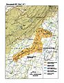
The lower Shawangunk habitat region as identified by the U.S. Fish and Wildlife Service
