Mount Hope, New York facts for kids
Quick facts for kids
Mount Hope, New York
|
|
|---|---|
| Town of Mount Hope | |

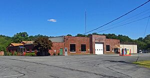
Town hall
|
|

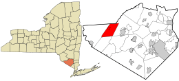
Location in Orange County and the state of New York.
|
|
| Country | United States |
| State | New York |
| County | Orange |
| Area | |
| • Total | 25.50 sq mi (66.03 km2) |
| • Land | 25.13 sq mi (65.10 km2) |
| • Water | 0.36 sq mi (0.94 km2) 1.22% |
| Elevation | 738 ft (225 m) |
| Population
(2020)
|
|
| • Total | 6,537 |
| • Density | 260.13/sq mi (100.41/km2) |
| Time zone | UTC-5 (Eastern (EST)) |
| • Summer (DST) | UTC-4 (EDT) |
| FIPS code | 36-48857 |
| GNIS feature ID | 0979241 |
Mount Hope is a small town in the northwestern part of Orange County, New York. It is located west of the city of Middletown. The northern edge of the town borders Sullivan County. In 2020, about 6,537 people lived in Mount Hope.
Contents
History of Mount Hope
The first European settler arrived in the area around 1733. The town of Mount Hope was officially formed in 1825. It was created from parts of two other towns: Deerpark and Wallkill.
Geography and Nature
Mount Hope covers a total area of about 25.5 square miles (66 square kilometers). Most of this area, about 25.2 square miles (65.1 square kilometers), is land. The rest, about 0.3 square miles (0.94 square kilometers), is water.
The Shawangunk Mountains are located along the western edge of the town. The Shawangunk Creek also flows through Mount Hope.
Getting Around
New York State Route 211 is a main highway that runs through Mount Hope from east to west. For those who travel by train, the Metro-North Railroad's Port Jervis Line has a station nearby in Otisville.
Population Facts
| Historical population | |||
|---|---|---|---|
| Census | Pop. | %± | |
| 1830 | 1,535 | — | |
| 1840 | 1,565 | 2.0% | |
| 1850 | 1,512 | −3.4% | |
| 1860 | 1,575 | 4.2% | |
| 1870 | 1,842 | 17.0% | |
| 1880 | 1,549 | −15.9% | |
| 1890 | 1,437 | −7.2% | |
| 1900 | 1,236 | −14.0% | |
| 1910 | 1,786 | 44.5% | |
| 1920 | 1,708 | −4.4% | |
| 1930 | 1,847 | 8.1% | |
| 1940 | 1,817 | −1.6% | |
| 1950 | 2,298 | 26.5% | |
| 1960 | 2,291 | −0.3% | |
| 1970 | 2,966 | 29.5% | |
| 1980 | 4,398 | 48.3% | |
| 1990 | 5,971 | 35.8% | |
| 2000 | 6,639 | 11.2% | |
| 2010 | 7,018 | 5.7% | |
| 2020 | 6,537 | −6.9% | |
| U.S. Decennial Census | |||
In 2000, there were 6,639 people living in Mount Hope. The population density was about 263.5 people per square mile (100.41 people per square kilometer). The town had 1,582 households. About 40.5% of these households had children under 18 living with them. The average household had about 2.93 people.
The population of Mount Hope has changed over the years. You can see how the number of people living in the town has grown and changed by looking at the chart above.
Places in Mount Hope
Mount Hope has several communities and important locations:
- Finchville – This is a small community in the southwestern part of the town. It is named after the first known settler in the area.
- Guymard – Another small community located in the southwestern part of the town, right on the town's border.
- Mount Hope – This is the main community or hamlet of Mount Hope. It is located south of Otisville.
- Otisville – A village found near the western edge of the town. It is located along New York State Route 211.
- Shawangunk Lake – A lake found at the eastern border of the town.
See also
 In Spanish: Mount Hope (Nueva York) para niños
 | John T. Biggers |
 | Thomas Blackshear |
 | Mark Bradford |
 | Beverly Buchanan |


