Crawford, New York facts for kids
Quick facts for kids
Crawford, New York
|
|
|---|---|
| Town of Crawford | |

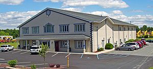
Crawford Town Hall, on NY 302 in Pine Bush
|
|

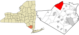
Location in Orange County and the state of New York.
|
|
| Country | United States |
| State | New York |
| County | Orange |
| Settled | 1740 |
| Established | 1823 |
| Government | |
| • Type | Town Council |
| Area | |
| • Total | 40.12 sq mi (103.90 km2) |
| • Land | 40.03 sq mi (103.68 km2) |
| • Water | 0.08 sq mi (0.22 km2) |
| Elevation | 486 ft (148 m) |
| Population
(2020)
|
|
| • Total | 9,130 |
| • Density | 227.57/sq mi (87.87/km2) |
| Time zone | UTC-5 (EST) |
| • Summer (DST) | UTC-4 (EDT) |
| FIPS code | 36-18916 |
| GNIS feature ID | 0978877 |
Crawford is a small town located in the northern part of Orange County, New York, in the United States. In 2020, about 9,130 people lived there. The town got its name from an early settler who also named a community within the area, which is now called Pine Bush.
Contents
History of Crawford
Crawford was first settled around 1740. It was originally part of another town called Montgomery. Crawford officially became its own town in 1823.
A long time ago, in 1813, Crawford was even known as the "butter capital of the world." This means it was a very important place for making and selling butter. Searsville was once a busy center for business and where the town government was located. However, when the railroad came to the area, it passed through a different part of town. This caused Searsville to lose its important role.
Geography of Crawford
The town of Crawford covers an area of about 40.2 square miles (103.9 square kilometers). Most of this area is land, about 40.1 square miles (103.68 square kilometers). Only a very small part, about 0.04 square miles (0.22 square kilometers), is water.
The northern border of Crawford is shared with Ulster County. Part of this border is marked by a small river called the Shawangunk Kill.
Important roads cross through Crawford. NYS Route 52 and NYS Route 302 meet in the community of Pine Bush. Another main road, NYS Route 17K, runs through the southern part of the town.
Who Lives in Crawford?
| Historical population | |||
|---|---|---|---|
| Census | Pop. | %± | |
| 1830 | 2,019 | — | |
| 1840 | 2,075 | 2.8% | |
| 1850 | 1,912 | −7.9% | |
| 1860 | 2,003 | 4.8% | |
| 1870 | 2,024 | 1.0% | |
| 1880 | 1,951 | −3.6% | |
| 1890 | 1,876 | −3.8% | |
| 1900 | 1,778 | −5.2% | |
| 1910 | 1,659 | −6.7% | |
| 1920 | 1,507 | −9.2% | |
| 1930 | 1,800 | 19.4% | |
| 1940 | 1,786 | −0.8% | |
| 1950 | 2,410 | 34.9% | |
| 1960 | 2,574 | 6.8% | |
| 1970 | 3,896 | 51.4% | |
| 1980 | 4,910 | 26.0% | |
| 1990 | 6,394 | 30.2% | |
| 2000 | 7,875 | 23.2% | |
| 2010 | 9,316 | 18.3% | |
| 2020 | 9,130 | −2.0% | |
| U.S. Decennial Census | |||
A census is an official count of how many people live in an area. In 2000, there were 7,875 people living in Crawford. These people lived in 2,707 households, and 2,133 of these were families. The population density was about 196 people per square mile.
Most people in Crawford in 2000 were white (95.59%). There were also smaller groups of African American, Native American, and Asian residents. About 5.13% of the population identified as Hispanic or Latino.
Many households (42.3%) had children under 18 living there. Most households (65.8%) were married couples. The average household had about 2.90 people, and the average family had about 3.29 people.
The population of Crawford includes people of all ages. In 2000, about 30.3% of the people were under 18 years old. About 9.2% were 65 years or older. The median age, which is the middle age of all the people, was 36 years.
The median income for a household in Crawford was $57,063 in 2000. For families, the median income was $63,722. A small number of families (2.7%) and people (4.0%) lived below the poverty line, which means they had very low incomes.
Places in Crawford
Crawford is made up of several smaller communities, often called hamlets. Here are some of them:
- Bullville – This hamlet is in the southern part of Crawford. You can find it where NY-17K and NY-302 roads meet.
- Collabar – Another hamlet located in the southern part of Crawford, along the NY-17K road.
- Hopewell – This was once a community in the town, but it is no longer active.
- Pine Bush – This hamlet is in the northwestern corner of the town. It used to be called "Crawford" itself. NY-52 and NY-302 roads cross paths here.
- Searsville – This hamlet is on County Road 17, located east of Thompson Ridge. It was once known as "Searsburg."
- Thompson Ridge – You can find this hamlet on NY-302, south of Pine Bush. The historic John I. Crawford Farm is located here. It was added to the National Register of Historic Places in 1998.
- Van Keuren – This hamlet is on NY-302, between Pine Bush and Thompson Ridge.
See also
 In Spanish: Crawford (Nueva York) para niños
 | Jewel Prestage |
 | Ella Baker |
 | Fannie Lou Hamer |


