Verkeerder Kill facts for kids
Quick facts for kids Verkeerder Kill |
|
|---|---|

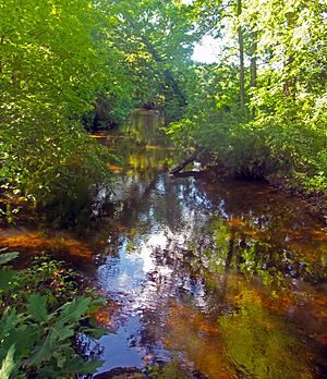
Verkeerder Kill at Verkeerder Kill Park
|
|
| Country | United States |
| State | New York |
| Region | Hudson Valley |
| County | Ulster |
| Towns | Wawarsing, Shawangunk |
| Physical characteristics | |
| Main source | Unnamed location on Shawangunk Ridge Wawarsing 2,060 ft (630 m) 41°41′41″N 74°19′39″W / 41.69472°N 74.32750°W |
| River mouth | Shawangunk Kill SW of Pine Bush 333 ft (101 m) 41°36′7″N 74°19′33″W / 41.60194°N 74.32583°W |
| Length | 8 mi (13 km), North-south |
The Verkeerder Kill is a small stream, about 8-mile-long (13 km), located in Ulster County, New York, United States. People sometimes call it Verkeerderkill or even Kaidy Kill for short. It starts high up on the Shawangunk Ridge in the town of Wawarsing. From there, it flows south through the town of Shawangunk. Eventually, it joins the Shawangunk Kill, which is a larger stream that flows into the Wallkill River. All these waterways are part of the Hudson River's watershed, meaning their water eventually flows into the Hudson River.
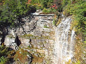
The Verkeerder Kill is most famous for the beautiful Verkeerder Kill Falls. This waterfall is 187-foot (57 m) tall and is found near where the stream begins. It sits right on the border between the two towns. The falls are a popular spot for hikers. You can reach them by following the Long Path, a long hiking trail that goes from New York City all the way to the Capital District.
Contents
The Stream's Journey: Where the Verkeerder Kill Flows
The Verkeerder Kill begins as two small streams. They are very close to each other in a special kind of dwarf pine barrens forest. This forest is on top of the Shawangunk Ridge in the Sam's Point Preserve. The highest part of the stream starts at about 2,060 feet (630 m) above sea level. After flowing about 500 feet (150 m) south, these two small streams meet and become the main Verkeerder Kill.
After another 500 feet (150 m), the stream flows over a bed of white stone. Here, the Verkeerder Kill Falls Trail, which is part of the Long Path, crosses the stream. Soon after, the stream reaches the tall cliffs of the Shawangunks. It then tumbles over Verkeerder Kill Falls, dropping 187 feet (57 m) into the town of Shawangunk. Below the falls, the stream continues to flow steeply down a wooded valley. It passes some remote houses as it heads south. About a mile (1.6 km) below the falls, another stream joins it from the northwest. This stream flows out of Lake Maratanza.
The Verkeerder Kill drops another 100 feet (30 m) in the next quarter-mile. Then, the ground becomes less steep. The stream has dropped about 1,200 feet (370 m) in elevation during its first 2.5 miles (4.0 km). About half a mile (800 m) further south, and 150 feet (46 m) below the ridge, it flows under Indian Springs Road. This is its first time crossing under a road. From here, it turns southeast, flowing under two dead-end roads in the next mile. It passes through woodlands with some open areas near the stream. The land around it becomes flat.
For the next mile, the Verkeerder Kill flows south again through thick forest. Just before it reaches a wetland about 500 feet (150 m) high, it turns southwest. Half a mile downstream, it turns southeast. Another stream, which flows from Murrays Pond, joins it from the west.
Soon after, the stream flows very close to Sinsabaugh Road. It follows the road as it bends southwest and then southeast again over the next mile. Here, the forests start to mix with farmland. The stream reaches the 83-acre (34 ha) Verkeerderkill Park on its west side. A thin line of trees separates the stream from open fields on both sides.
At the park's southeast corner, the stream flows under New York State Route 52. It is now at an elevation of 416 feet (127 m). The stream winds a bit as more woodlands appear. Then, it goes back to flowing south as it passes under Johns Estate Road. Again, a path of trees follows the stream through fields. It starts to loop around the small hamlet of Ulsterville. It curves south to cross under Burlingham Road (County Route 7). Then it briefly turns northeast and then east through woods again. Here, it crosses under Ulsterville Road. It flows next to that street, turning southwest and crossing Seely Road twice, then Pirog Road. Finally, it flows into the Shawangunk Kill just north of the Ulsterville Road bridge. This is near the Orange County line, south of the hamlet of Pine Bush. The stream is about 333 feet (101 m) above sea level here.
History of the Verkeerder Kill's Name
We don't know if the Iroquois or other Native American tribes had a name for this stream. If they did, it was not written down before Europeans came to America. The first time the stream is mentioned is in a land document from 1717 by Johannes Hardenbergh. In this document, the stream is called Verkerde Kill. Hardenbergh also noted that it was sometimes called Pakanasink Creek. Today, Pakanasink Creek is the name of a different stream that joins the Shawangunk Kill a little further downstream.
According to Marc Fried, a historian who studies the Shawangunks, the name "Verkeerder Kill" comes from the Dutch words for "wrong brook." Dutch was the language spoken by Hardenbergh and other early settlers who moved into the Shawangunk Valley in the late 1600s.
Why was it called "wrong brook"? This has always been a bit of a puzzle. At first, Fried thought maybe the stream was flooding when the first explorers saw it. Or perhaps someone fell in and angrily named it "wrong." But then he talked to an expert on the New Netherland era. The expert told him that if they meant "wrong" in a bad way, they would have used a stronger Dutch word like slecht or kwaad.
This made Fried think that maybe the name just meant it was "incorrect." The name "Pakanasink" had been used since 1684 for the land around the lower part of the Verkeerder Kill, where Ulsterville is now. The Shawangunk Kill was also sometimes called Pakanasink Creek back then. Fried thought that maybe a group of explorers came to the area later. They might have thought the stream flowing in from the west was the Pakanasink. But then they learned that name was already used for the Shawangunk Kill. So, they might have started calling this western stream "the wrong brook." This name could have stuck, even after people understood the difference.
During the 1800s, the stream got another name that people still use today. Locals started calling it Kaidy Kill or Cater Kill. They found the full name too hard to say. An 1899 map shows both the long and short names for the stream. This sometimes caused confusion with Kaaterskill Creek, a stream in Greene County that flows down from the Catskill Escarpment. One old guidebook even described Verkeerderkill Falls as being 240 feet (73 m) tall, which is actually the height of Kaaterskill Falls. The shorter name was so common that a woman born in nearby Ellenville in the early 1900s told Fried she always knew it as Kaidy Kill. She didn't even know it had a longer name until he showed it to her on a map!
Ecology: Life in the Verkeerder Kill
The Verkeerder Kill is surrounded by large forests for most of its path. This means it stays quite clean. New York's Department of Environmental Conservation has given it a Class A rating. This means the water is clean enough for all human uses, including drinking. In 2002, scientists studied the tiny creatures living in the stream near the Ulsterville Road bridge. They found many different kinds of macroinvertebrates there. This showed that the water was healthy and could support a lot of aquatic life.
Crossings: Where Roads Meet the Stream
- Verkeerderkill Falls Trail (part of Long Path) via ford
- Indian Springs Road/Oregon Trail
- Indian Springs Camp Road
- Forestdale Lane
- New York State Route 52
- Johns Estate Road
- Burlingham Road (Ulster County Route 7)
- Ulsterville Road
- Pirog Road
 | Sharif Bey |
 | Hale Woodruff |
 | Richmond Barthé |
 | Purvis Young |


