Sheep Hole Mountains facts for kids
Quick facts for kids Sheep Hole Mountains |
|
|---|---|
| Highest point | |
| Elevation | 1,057 m (3,468 ft) |
| Geography | |
| Country | United States |
| State | California |
| District | San Bernardino County |
| Range coordinates | 34°11′38.009″N 115°39′18.968″W / 34.19389139°N 115.65526889°W |
| Topo map | USGS Dale Lake |
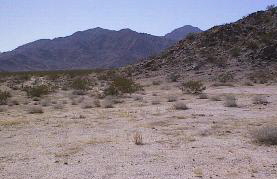
The Sheep Hole Mountains are a group of mountains in the Mojave Desert in California. They are located north of Joshua Tree National Park, in an area called San Bernardino County. Long ago, these mountains were important hunting grounds for the Chemehuevi people.
This mountain range sits between the Bullion Mountains to the west and the Coxcomb Mountains to the east. The highest point in the Sheep Hole Mountains reaches about 4,613 feet (1,406 meters) above sea level. You can find this peak just east of Amboy Road, which actually crosses through the range.
Exploring the Sheephole Valley Wilderness
A special area within the Sheep Hole Mountains is called the Sheephole Valley Wilderness Area. The Bureau of Land Management looks after and protects this large wilderness. It is also part of the Mojave Trails National Monument.
This wilderness area covers about 194,861 acres. It's a great example of the "basin and range" landscape. This means it has long mountain ranges (the "range") separated by flat valleys (the "basin"). The Sheephole Valley Wilderness includes the Sheep Hole Mountains and the Calumet Mountains. These mountains are full of granite boulders. The wilderness area is also right next to the northern edge of Joshua Tree National Park.
 | Bessie Coleman |
 | Spann Watson |
 | Jill E. Brown |
 | Sherman W. White |


