Sherman, Mississippi facts for kids
Quick facts for kids
Sherman, Mississippi
|
|||
|---|---|---|---|

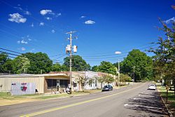
Main Street
|
|||
|
|||

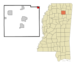
Location of Sherman, Mississippi
|
|||
| Country | United States | ||
| State | Mississippi | ||
| Counties | Pontotoc, Union, Lee | ||
| Area | |||
| • Total | 1.74 sq mi (4.51 km2) | ||
| • Land | 1.74 sq mi (4.51 km2) | ||
| • Water | 0.00 sq mi (0.00 km2) | ||
| Elevation | 367 ft (112 m) | ||
| Population
(2020)
|
|||
| • Total | 600 | ||
| • Density | 344.63/sq mi (133.04/km2) | ||
| Time zone | UTC-6 (Central (CST)) | ||
| • Summer (DST) | UTC-5 (CDT) | ||
| ZIP code |
38869
|
||
| Area code(s) | 662 | ||
| FIPS code | 28-67200 | ||
| GNIS feature ID | 2407325 | ||
Sherman is a town located across three counties in Mississippi: Lee, Pontotoc, and Union. In 2020, about 600 people lived there.
The Story of Sherman
In 1840, two people named Reuben Jones and John Witt started a community where Sherman is today. It was about 14 miles northeast of Pontotoc. But the town really grew because of the Kansas City, Memphis and Birmingham Railroad.
When trains started running on the new railroad in 1886, a train station was built. A person who used to live in Sherman, Texas named the station "Sherman." R.P. Kelly built the first house in the spring of 1886. Other important people and business owners in the early town were John Witt, J.E. Wade, and John Johnson.
Education in Early Sherman
The Mississippi Normal Institute was started in 1889 by Professor J.N. Davis. It even had a place for students to live. The institute was very popular for several years, with 300 students.
However, as public schools became more common, fewer students attended the institute. Around 1903, it joined with the public school in Sherman.
Sherman in 1890
An old newspaper, the Pontotoc Democrat, wrote about Sherman on September 19, 1890. It described the town as a "thriving little town." It was 94 miles from Memphis and 158 miles from Birmingham by train.
The newspaper said Sherman's population had almost doubled in one year. It was surrounded by the best farming lands in the state. At that time, Sherman had 35 homes, 6 stores, and 2 doctors. The newspaper also mentioned a school building and predicted Sherman would become very important in education.
Where is Sherman Located?
Sherman is located northwest of Tupelo. Most of the town is north of Interstate 22 and south of Mississippi Highway 178.
Most of Sherman is in Pontotoc County. A part of it goes north into Union County, and a very small part extends east into Lee County. In the year 2000, most of the town's residents lived in Pontotoc County.
Population Information
| Historical population | |||
|---|---|---|---|
| Census | Pop. | %± | |
| 1890 | 79 | — | |
| 1900 | 300 | 279.7% | |
| 1910 | 353 | 17.7% | |
| 1920 | 421 | 19.3% | |
| 1930 | 464 | 10.2% | |
| 1940 | 449 | −3.2% | |
| 1950 | 386 | −14.0% | |
| 1960 | 403 | 4.4% | |
| 1970 | 468 | 16.1% | |
| 1980 | 499 | 6.6% | |
| 1990 | 528 | 5.8% | |
| 2000 | 548 | 3.8% | |
| 2010 | 650 | 18.6% | |
| 2020 | 600 | −7.7% | |
| U.S. Decennial Census | |||
Sherman's Population in 2020
In 2020, the 2020 United States Census counted 600 people living in Sherman. There were 289 households and 180 families in the town.
| Race | Num. | Perc. |
|---|---|---|
| White | 409 | 68.17% |
| Black or African American | 136 | 22.67% |
| Native American | 1 | 0.17% |
| Asian | 5 | 0.83% |
| Pacific Islander | 1 | 0.17% |
| Other/Mixed | 30 | 5.0% |
| Hispanic or Latino | 18 | 3.0% |
Schools in Sherman
The town of Sherman is served by three different school districts. This depends on which county a part of the town is in.
- Most of the town is part of the Pontotoc County School District.
- The part of town in Union County is served by the Union County School District.
- The small part of Sherman in Lee County is served by the Lee County School District.
Famous People from Sherman
- Dode Criss was a Major League Baseball pitcher who played professionally.
See also
 In Spanish: Sherman (Misisipi) para niños
 | George Robert Carruthers |
 | Patricia Bath |
 | Jan Ernst Matzeliger |
 | Alexander Miles |


