
Sherwood, Tennessee facts for kids
Quick facts for kids
Sherwood, Tennessee
|
|
|---|---|

Post office and houses
|
|

Sherwood, Tennessee
Location in Tennessee

Sherwood, Tennessee
Location in the United States
|
|
| Country | United States |
| State | Tennessee |
| County | Franklin |
| Area | |
| • Total | 0.91 sq mi (2.35 km2) |
| • Land | 0.91 sq mi (2.35 km2) |
| • Water | 0.00 sq mi (0.00 km2) |
| Elevation | 669 ft (204 m) |
| Population
(2020)
|
|
| • Total | 122 |
| • Density | 134.51/sq mi (51.95/km2) |
| Time zone | UTC-6 (Central (CST)) |
| • Summer (DST) | UTC-5 (CDT) |
| ZIP code |
37376
|
| Area code(s) | 931 |
| GNIS feature ID | 1303571 |
Sherwood is a small place in Franklin County, Tennessee, USA. It's not a city with its own government, but a community. You can find it along Tennessee State Route 56, about 13 miles (21 km) southeast of Winchester. It's also very close to the border of Alabama. Sherwood has its own post office with the ZIP code 37376.
Contents
People Living in Sherwood
| Historical population | |||
|---|---|---|---|
| Census | Pop. | %± | |
| 2020 | 122 | — | |
| U.S. Decennial Census | |||
In 2020, about 122 people lived in Sherwood. This number comes from the official count of people in the United States, called the U.S. Decennial Census.
Where is Sherwood?
Sherwood is located in the Crow Creek Valley. This valley is quite narrow. It has tall hills of the Cumberland Plateau on three sides: north, east, and west. The southern part of the valley opens up towards Alabama.
Crow Creek flows through this valley. It starts from Lost Cove Cave and goes through the western part of Sherwood. The creek eventually flows into the Tennessee River at Guntersville Lake in Alabama. Sherwood is about 669 feet (204 meters) above sea level.
Tennessee State Route 56 is the main road that goes through Sherwood. It runs from north to south. If you go north, the road climbs over 1,000 feet (305 meters) to Sewanee on top of the Cumberland Plateau. If you go south, the road continues into Alabama as State Route 117. It eventually reaches Stevenson, Alabama. Train tracks also run next to the highway for most of its path through the valley.
Sherwood's Past
People have lived in the Sherwood area for a very long time. Thousands of Native American tools have been found in nearby fields. The town is located where many old Native American paths crossed. Modern roads often follow these same routes.
Sherwood used to be a small community called Kitchen's Station or Catchings Station. It was a stop for stagecoaches. The community was named after the station master, Meridith Catchings. It started showing up on railroad maps after the Civil War.
How Sherwood Got Its Name
The town of Sherwood was named after Charles D. Sherwood. He was the lieutenant governor of Minnesota during the Civil War. In 1878, he started a company called the Tennessee Immigration and Land Company. On April 15, 1878, he bought 1,410 acres of land for his new community. A local newspaper announced on June 19, 1878, that Kitchen's Station would be renamed Sherwood.
In 1989, the Sherwood Elementary School closed. The children from Sherwood then started going to Sewanee Public School.
The Railroad in Sherwood
A very important train tunnel, the Cowan Tunnel, was built about 5 miles (8 km) north of Sherwood in 1852. Because of this, train stops were made along the Crow Creek Valley, including at Catchings Station (Sherwood).
Sherwood was a special stop for "pusher engines." These are extra engines needed to help trains climb the steep mountain up to the tunnel. There are also pusher engines on the other side of the tunnel in Cowan, Tennessee.
Sadly, in 1915, a passenger train and a freight train crashed in Sherwood. This accident killed fifteen people and injured twenty-two others.
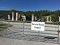
Gager Lime Company

The Gager Lime Manufacturing Company was started by Byron Gager in 1892. This company dug up limestone and made lime in the community. The lime factory worked until 1949.
In 1930, Sherwood had 1,700 people living there. But after the limestone factory closed, the town's economy slowed down. By the 1950s, the population dropped to 900.
Today, you can still see the castle-like ruins of the old lime factory and its storage towers. These buildings have unusual Egyptian Revival and Gothic Revival styles. They are considered important historical buildings.
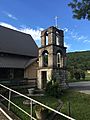
Epiphany Mission

In 1899, the Epiphany Episcopal Mission was started in Sherwood. The Episcopal church began providing schooling for local children. The first church building was built in 1902. It was replaced in 1928, but then burned down in 1960. A new church was built in 1967. Parts of the 1928 building are still kept as ruins on the church grounds.
During the Great Depression, a priest named Father George Jones wrote pamphlets to raise money for the community. These pamphlets were later published as a book in 1954.
In 1956, the mission helped train women and opened a shirt factory in Sherwood. This was an effort to create jobs for people in the area.
Painted Snake-Coiled Forest Snail

The painted snake-coiled forest snail is a very special animal. It is only found in the Sherwood area! This snail was first discovered here in 1906. Because it is so rare, it was named a threatened species in 1978.
This snail is also known as the painted tigersnail. It is a type of land snail that breathes air. It belongs to a group of snails called disc snails.
Images for kids
-
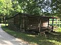
Old Log Cabin
-
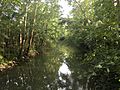
Crow Creek
-
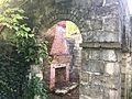
Epiphany Mission Ruined Fireplace
-
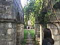
Epiphany Mission Central Ruin
-
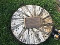
Epiphany Mission Historical Plaque
-
Epiphany Mission Old Bell Tower
-
Gager Mining Company Ruins Entrance


