Shire of West Arthur facts for kids
Quick facts for kids Shire of West ArthurWestern Australia |
|||||||||||||||
|---|---|---|---|---|---|---|---|---|---|---|---|---|---|---|---|

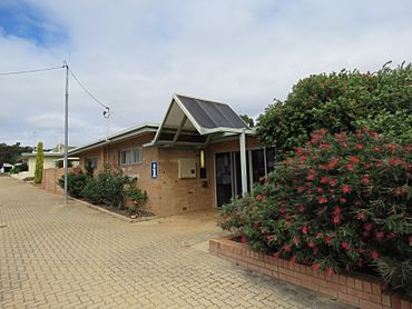
Shire Of West Arthur offices
|
|||||||||||||||

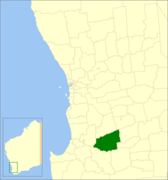
Location in Western Australia
|
|||||||||||||||
| Established | 1896 | ||||||||||||||
| Area | 2,834.2 km2 (1,094.3 sq mi) | ||||||||||||||
| Shire President | Neil Morrell | ||||||||||||||
| Council seat | Darkan | ||||||||||||||
| Region | Wheatbelt | ||||||||||||||
| State electorate(s) | Roe | ||||||||||||||
| Federal Division(s) | O'Connor | ||||||||||||||
 |
|||||||||||||||
| Website | Shire of West Arthur | ||||||||||||||
|
|||||||||||||||
The Shire of West Arthur is a special area in Western Australia, located in the Wheatbelt region. It's like a local government area, meaning it has its own council that helps manage the community. This shire is about 200 kilometers (124 miles) south-east of Perth, the state capital.
The Shire of West Arthur covers a large area of about 2,834 square kilometers (1,094 sq mi). The main town and where the local government offices are is called Darkan.
The businesses in the Shire of West Arthur are very important to Western Australia's economy, bringing in about $45 million each year! The main activities here are raising sheep and producing wool. But that's not all! They also work with timber, grow grain, manage forests, raise beef cattle and pigs, and even process animal hides. There are also engineering and earthmoving businesses.
Contents
History of West Arthur
The Shire of West Arthur has a long history, starting way back on January 10, 1896. Back then, it was called the West Arthur Road District. This was a common way to manage local areas in the past.
On July 1, 1961, things changed! A new law called the Local Government Act 1960 made all road districts become "shires." So, the West Arthur Road District officially became the Shire of West Arthur. Its name comes from its location near the former Arthur Road District, which was later renamed to Wagin in 1905.
How the Shire is Governed
The Shire of West Arthur is managed by a group of people called councillors. These councillors are elected by the people who live in the shire. They make decisions about local services and how the area is run.
Before October 20, 2007, the shire was divided into four smaller areas called "wards." Each ward had its own councillors. But now, the system is simpler! All nine councillors represent the entire shire, meaning they work for everyone living there.
Towns and Localities
The Shire of West Arthur is home to several towns and smaller communities, which are also called localities. Each of these places has its own unique character. The main town and the center of the shire is Darkan.
Other localities in the shire include:
- Arthur River
- Bokal
- Bowelling
- Duranillin
- Mokup
- Moodiarrup
- Trigwell
There was also a former town called Boolading in the shire's history.
Population Changes Over Time
The number of people living in the Shire of West Arthur has changed quite a bit over the years. Here's a quick look at how the population has grown and shrunk:
- In 1911, there were 674 people.
- By 1954, the population had grown to 1,295.
- It reached its highest point in 1966 with 1,427 residents.
- Since then, the population has generally decreased.
- In 2021, the population was 773 people.
Heritage Places
The Shire of West Arthur has many important historical sites! As of 2023, there are 60 places in the shire that are recognized for their heritage. This means they are special because of their history or cultural importance.
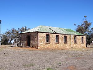
Out of these 60 places, three are so important that they are listed on the State Register of Heritage Places. This is a special list for the most significant heritage sites in Western Australia. One example is the Old Tillellan Shearing Quarters at Arthur River, which you can see in the image below.
 | Georgia Louise Harris Brown |
 | Julian Abele |
 | Norma Merrick Sklarek |
 | William Sidney Pittman |


