Shirley, New York facts for kids
Quick facts for kids
Shirley, New York
|
|
|---|---|

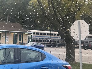
Mastic-Shirley station
|
|
| Motto(s):
Long Island's Best Kept Secret
|
|
 |
|
| Country | United States |
| State | New York |
| County | Suffolk |
| Town | Brookhaven |
| Area | |
| • Total | 12.17 sq mi (31.52 km2) |
| • Land | 11.31 sq mi (29.30 km2) |
| • Water | 0.85 sq mi (2.21 km2) |
| Elevation | 52 ft (16 m) |
| Population
(2020)
|
|
| • Total | 26,360 |
| • Density | 2,329.86/sq mi (899.57/km2) |
| Time zone | UTC-5 (Eastern (EST)) |
| • Summer (DST) | UTC-4 (EDT) |
| ZIP code |
11967
|
| Area code(s) | 631, 934 |
| FIPS code | 36-67070 |
| GNIS feature ID | 0970601 |
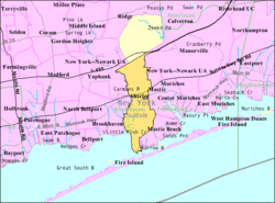
Shirley is a small community in Suffolk County, New York. It is called a hamlet and also a census-designated place. In 2020, about 26,360 people lived here.
Shirley is very important for connecting the internet! It is where a big underwater cable called Atlantic Crossing 1 comes ashore. This cable helps link the United States with the UK, Germany, and the Netherlands. Another new cable, the Emerald Express, will also connect Europe and North America through Shirley.
This community is part of the Town of Brookhaven. It sits on the South Shore of Long Island. Shirley was named after Walter T. Shirley. In the 1940s, he wanted to build affordable homes here. His company sold 4,000 homes for about $4,700 each.
Shirley has its own train station, the Mastic–Shirley Long Island Rail Road station. This station was built after both Mastic and Shirley communities asked for it. The Smith Point Bridge is also in Shirley. It is one of only two bridges that connect Long Island to Fire Island. This bridge makes it easy for people to visit the ocean beaches without needing a ferry.
The local police department, the 7th Precinct of the Suffolk County Police Department, is located in Shirley. Most of Shirley is served by the William Floyd School District. The northern part of Shirley is served by the Longwood Central School District.
Shirley used to be called Tangiers. This name came from William "Tangier" Smith. In the early 1900s, it was a popular spot for summer bungalows. Many people from New York City came here to escape the busy city. Some of these old bungalows are still standing today.
Contents
Shirley's Location and Area
Shirley is located at 40°47′49″N 72°52′16″W / 40.79694°N 72.87111°W.
The United States Census Bureau says that Shirley covers about 30.8 square kilometers (11.9 square miles). Most of this area, about 29.7 square kilometers (11.5 square miles), is land. The rest, about 1.1 square kilometers (0.4 square miles), is water.
The northern part of Shirley is sometimes called East Yaphank. This area shares the same ZIP code, 11967. The postal service accepts Shirley, Smith Point, or East Yaphank for this neighborhood.
People Living in Shirley
| Historical population | |||
|---|---|---|---|
| Census | Pop. | %± | |
| 2020 | 26,360 | — | |
| U.S. Decennial Census | |||
In 2000, there were 26,395 people living in Shirley. There were 7,353 households, which are groups of people living together. About 47.2% of these households had children under 18 years old. Most households (64.4%) were married couples.
The population in Shirley is quite young. About 31.2% of the people were under 18 years old. The average age was 32 years. In 2011, the average household income was estimated to be $82,791.
Media and Radio
Shirley is home to W243BF, which is a radio station. This station is officially licensed to serve the Shirley area.
Famous People From Shirley
Shirley has been home to some well-known people:
- Frank Coraci, a film director
- Al Plastino, an artist famous for his work on DC Comics like Superman and Batman
- Cletus Seldin (born 1986), a professional boxer
- Lee Zeldin, a United States congressman]
See also
 In Spanish: Shirley (Nueva York) para niños
 | Georgia Louise Harris Brown |
 | Julian Abele |
 | Norma Merrick Sklarek |
 | William Sidney Pittman |


