
Shoshone Lake facts for kids
Quick facts for kids Shoshone Lake |
|
|---|---|

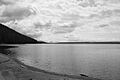
Shoshone Lake in 1988
|
|

Shoshone Lake
Location in Wyoming

Shoshone Lake
Location in the United States
|
|
| Location | Yellowstone National Park, Teton County, Wyoming, U.S. |
| Coordinates | 44°22′20″N 110°42′45″W / 44.37222°N 110.71250°W |
| Primary outflows | Lewis River |
| Basin countries | United States |
| Surface area | 8,050 acres (32.6 km2) |
| Max. depth | 205 feet (62 m) |
| Surface elevation | 7,795 feet (2,376 m) |
Shoshone Lake is a large lake located deep inside Yellowstone National Park in Wyoming, USA. It covers about 8,050 acres (32.6 square kilometers) and sits high up at 7,795 feet (2,376 meters) above sea level. This beautiful lake is special because it's considered the biggest "backcountry" lake in the lower 48 states. "Backcountry" means you can't reach it by car; you have to hike or boat to get there.
The lake is the starting point for the Lewis River, which then flows into the Snake River.
Contents
The Story of Shoshone Lake's Name
Shoshone Lake has had many different names over the years. Early explorers and mapmakers each gave it a new name.
Early Explorers and Their Names
- 1830s - Snake Lake: Fur trappers were the first non-Native Americans to see the lake in the early 1800s. Famous mountain man Jim Bridger likely visited in 1833 and definitely in 1846. Another trapper, Osborne Russell, explored the lake in 1839. They called it Snake Lake.
- 1851 - DeSmet's Lake: A map made by Father Pierre-Jean De Smet in 1851 showed the lake with his own name.
- 1863 - DeLacy's Lake: Walter DeLacy, a mapmaker from Montana, named it DeLacy's Lake when he traveled through the area.
Later Expeditions and Name Changes
- 1869 - Cook–Folsom–Peterson Expedition: This group camped by the lake but didn't give it a name in their journals. They mistakenly thought it was the source of the Firehole and Madison Rivers.
- 1870 - Washburn-Langford-Doane Expedition: This expedition also thought Shoshone Lake was the source of the Madison River. Cornelius Hedges, a member of the group, named it Washburn Lake after their leader, Henry D. Washburn. But this name didn't last long.
- 1871 - Hayden Geological Survey: A. C. Peale, part of this survey, visited the lake and called it Madison Lake.
- 1872 - Shoshone Lake is Named: Finally, during the 1872 Hayden Geologic Survey, Frank Bradley confirmed that the lake was part of the Snake River system. He then named it Shoshone Lake, using the Native American name for the Snake River. This name stuck!
Shoshone Geyser Basin

At the southwest end of Shoshone Lake, you'll find the amazing Shoshone Geyser Basin. This area is packed with more than 80 geysers in a space about 1,600 feet (488 meters) long and 800 feet (244 meters) wide. It's one of the places with the most geysers in the world! You can also see hot springs and bubbling mudpots scattered around the landscape between the geyser basin and the lake.

Fishing and Boating at Shoshone Lake
Shoshone Lake is a popular spot for outdoor activities, especially fishing and boating.
Fish in the Lake
Before 1890, there were no fish in Shoshone Lake. This was because Lewis Falls on the Lewis River blocked fish from swimming upstream into the lake. But in 1890, people brought and released fish into the lake. They introduced Lake and Brown trout, which created a great place for fishing. The lake also has Utah chub, which were probably accidentally brought in by people using them as bait in the 1950s. You might also find Brook trout in the lake, as they were planted in some of the streams that flow into it.
Rules for Angling
If you want to fish in Shoshone Lake, you can only use fly fishing gear or artificial lures. You can't use live bait.
Boating and Access
Boating on Shoshone Lake is only allowed for hand-powered boats. This means you can use Float tubes, Kayaks, or Canoes. Motorized boats are not allowed.
You can reach the lake by water through Lewis Lake and the Lewis River channel. There are also several trails that lead to the western, northern, and eastern shores of the lake.
- The Shoshone Lake trail connects the Upper Geyser Basin with the Lewis River channel. It also passes through the Shoshone Geyser Basin.
- The DeLacy Creek trail gives you access to the northern and eastern parts of the lake from the Grand Loop Road near Craig Pass.
- The Dogshead trail and Lewis River Channel trail provide access from the south entrance road near Lewis Lake.
There are 20 campsites around Shoshone Lake where you can stay overnight in the backcountry.
Images for kids
-
Shoshone Lake
-
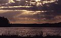
Sunset, 1970
-
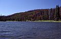
Lewis River Channel Outlet, 1989


