
Shrewley Tunnel facts for kids
 |
|
| Northern entrance to Shrewley Tunnel | |
| Overview | |
|---|---|
| Location | Shrewley, Warwickshire, England |
| Coordinates | 52°18′09″N 1°41′15″W / 52.302598°N 1.687555°W |
| OS grid reference | SP213672 |
| Status | Open |
| Waterway | Grand Union Canal |
| Operation | |
| Owner | British Waterways |
| Technical | |
| Length | 433 yards (395.9 m) |
| Towpath | No (Separate tunnel) |
| Boat-passable | Yes |
The Shrewley Tunnel is a canal tunnel located near the village of Shrewley in Warwickshire, England. It first opened in 1799. This historic tunnel is an important part of the Grand Union Canal, a major waterway in Britain. It became part of this larger canal system in 1929.
Contents
How the Shrewley Tunnel Was Built
Planning the Canal Route
In March 1793, a company called the Warwick and Birmingham Canal Company got a special law from Parliament. This law allowed them to build a new canal. The canal would be about 22.6-mile (36.4 km) long. It would connect the Digbeth Branch Canal in Birmingham to Warwick. The plans for this new canal included three tunnels. These tunnels were meant to go through hills at Shrewley, Rowington, and Yardley.
Changing Plans for the Tunnels
As the canal was being built, the engineers found a different way to cross the land at Rowington and Yardley. Instead of tunnels, they made "deep cuttings." These are like very deep ditches dug into the ground. However, this was not possible at Shrewley. The canal route here went right under the village. So, a tunnel was still needed for Shrewley.
Making the Tunnel Wider
The first plans for Shrewley Tunnel said it would be narrow. It was only meant for "narrow boats," which were about 7-foot (2.1 m) wide. These boats were common on the Birmingham canals. But at the same time, another big canal project was starting. This was the Grand Junction Canal, which would link to London.
The canal company decided to be smart. In April 1794, they chose to make Shrewley Tunnel much wider. They increased its width to 16 feet (4.9 m). This wider tunnel could now fit "wide barges." These are bigger boats that were used on other canals. They also made the bridge openings wider, at 21 feet (6.4 m). This was a good decision because it meant more types of boats could use the canal.
Opening the Tunnel
The Shrewley Tunnel is 433 yards (396 m) long. It is built from brick and is wide enough for two narrow boats to pass each other. However, there is no path inside the tunnel for horses to pull the boats. The tunnel officially opened on December 19, 1799. This was when the rest of the Warwick and Birmingham Canal was finished. Boats started using it for trade in March of the next year. In 1929, the canal company joined with others, including the Grand Junction. This is how the Shrewley Tunnel became part of the Grand Union Canal.
The Special Horse Tunnel
Interestingly, there are actually two tunnels at Shrewley. At the northern end, the path for horses splits off. It goes up a ramp and enters its own separate tunnel. This "horse tunnel" goes under the road that crosses the main canal tunnel. After the road, the path goes down another ramp to meet the canal again at the southern end. Inside the main tunnel, it is often quite wet. This has led to cool rock formations called flowstone growing on the walls.
Where is Shrewley Tunnel?
The Shrewley Tunnel runs in a direction from the south-east to the north-west. From the northern end of the tunnel, the canal stays level for about 6.5 miles (10.5 km). Then, it reaches a set of five locks at Knowle. These locks raise the canal's water level by 41.8 feet (12.7 m).
About halfway along this level section is Kingswood Junction. This is where the Grand Union Canal connects to the Stratford-upon-Avon Canal. To the south of the tunnel, the canal is level for about 1.7 miles (2.7 km). After this, you reach Hatton Top Lock. This is the first of a famous set of 21 locks called the Hatton Locks. These locks lower the canal's water level by 146.5 feet (44.7 m) to reach the town of Warwick.
Images for kids
-
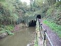
Northern entrance to the canal and accompanying horse tunnel

