
Sierra Prieta facts for kids
Quick facts for kids Sierra Prieta |
|
|---|---|

Thumb Butte, at Prescott's west side
|
|
| Highest point | |
| Peak | Granite Mountain |
| Elevation | 7,626 ft (2,324 m) |
| Dimensions | |
| Length | 16 mi (26 km) NW-SE |
| Geography | |

Location in Arizona
|
|
| Country | United States |
| Communities | Prescott, Skull Valley, Iron Springs, Highland Pines and Williamson Valley |
| Range coordinates | 34°32′17″N 112°35′24″W / 34.538°N 112.59°W |
The Sierra Prieta is a mountain range about 14 miles (23 km) long in central-northwest Arizona. It's located west of Prescott, and you can see a famous landmark called Thumb Butte there. Thumb Butte is about 6,514 feet (1,985 meters) tall and is actually an old volcanic plug!
The Sierra Prieta connects to the Bradshaw Mountains in the northwest. Granite Mountain, a popular spot for hiking and rock climbing, is also part of this range. It looks over Williamson Valley to the northeast. This mountain range is near the edge of the Arizona transition zone, which is famous for its big cliff called the Mogollon Rim.
About the Sierra Prieta Mountains
The Sierra Prieta mountains mostly stretch from the northwest to the southeast. In the south, the highest point is Mount Francis, standing at about 7,110 feet (2,167 meters). It's right next to the Bradshaw Mountains. Arizona State Route 89 is a road that goes between these two mountain ranges.
The highest point in the entire Sierra Prieta range is Granite Mountain, which is about 7,626 feet (2,324 meters) tall. It's located in the northern part of the range. Other peaks nearby include Little Granite Mountain (about 7,082 feet or 2,159 meters) and Tonto Mountain (about 5,631 feet or 1,716 meters). In the center of the range, you'll find West Spruce Mountain (about 7,160 feet or 2,182 meters) and Williams Peak (about 7,055 feet or 2,150 meters).
Roads and Travel
Besides Arizona State Route 89, which goes southwest from Prescott, there's also County Road 10. This road goes up to Iron Springs through Iron Springs Pass in the northern part of the range. People often use this road in winter when there's snow, as it's a shorter way through the lower elevation Skull Valley.
A Famous Cowboy Poem
The Sierra Prieta range is well-known among cowboys around the world. They sometimes call it "The Sierry Petes." This name comes from a famous cowboy poem by Arizonan Gail Gardner. The poem is officially called "Tyin' A Knot In The Devil's Tail."
Images for kids
-
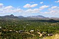
Northerly view of Thumb Butte, Granite Mountain massif, and S & W Prescott.
(The Sierra Prieta is to the photo-left.)

