Sierra de Ajusco-Chichinauhtzin facts for kids
Quick facts for kids Sierra de Ajusco-Chichinauhtzin |
|
|---|---|

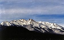
View of the summits of Ajusco
|
|
| Highest point | |
| Peak | Ajusco |
| Elevation | 12,894 ft (3,930 m) |
| Naming | |
| Etymology | Spanish for mountain range |
| Nickname | Serranía del Ajusco or Sierra de Chichinauhtzin |
| Geography | |
| Country | Mexico |
| Geology | |
| Age of rock | Quaternary period |
| Type of rock | batholith and igneous |
The Sierra del Ajusco-Chichinauhtzin is a mountain range in Mexico. It is also known as the Serranía del Ajusco or Sierra de Chichinautzin. This mountain range sits between Mexico City and the states of Morelos and Mexico. It forms the southern edge of the mountains surrounding Mexico City.
This range has over 100 volcanic cones. Some of the important peaks include Tláloc (3,690 meters above sea level), Chichinauhtzin (3,430 meters), Xitle (3,100 meters), Cerro Pelado (3,600 meters), and Cuauhtzin (3,510 meters). The highest point is the Cruz del Marqués peak on the Ajusco volcano, which reaches 3,937 meters (12,894 feet).
Contents
Where is the Ajusco-Chichinauhtzin Range?
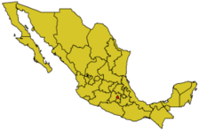
This mountain range covers parts of several areas. In Mexico City, it includes parts of Tlalpan, Xochimilco, Tláhuac, Milpa Alta, and Magdalena Contreras. It also extends into the state of Morelos, covering parts of Huitzilac, Tepoztlán, and Tlalnepantla. In the State of Mexico, it includes parts of Juchitepec and Tepetlixpa.
The Sierra del Ajusco-Chichinauhtzin is the highest point on the southern side of Mexico City. It creates a natural border, separating the Valley of Mexico from the Cuernavaca Valley and the Tepozteco mountain range.
How Did These Mountains Form?
The Ajusco-Chichinauhtzin range formed during the Quaternary period. This was a time of strong volcanic activity. The volcanoes created a natural barrier that closed off the Mexico Basin. This basin used to drain into the Balsas River, but the new mountains blocked that path.
The Ajusco volcano is part of a larger group of volcanoes and lakes in the Anahuac region. This entire area is part of the Trans-Mexican Volcanic Belt, a long chain of volcanoes across Mexico.
Nature and Wildlife in the Range
The Sierra del Ajusco-Chichinauhtzin is a very important natural area. It includes the Cumbres del Ajusco National Park. The whole region is also part of the Ajusco Chichinautzin Biological Corridor. This corridor helps protect the plants and animals that live there.
The area has many different types of habitats and species. This is because of its unique geography and climate. Scientists have found a huge variety of life here:
- Over 315 types of fungi (like mushrooms).
- 10 types of amphibians (like frogs and salamanders).
- 43 types of reptiles (like snakes and lizards).
- 1,348 types of insects and spiders.
- 237 types of birds, with 36 found only in this region.
- 5 types of fish.
- 785 types of plants.
- 7 different types of natural plant communities.
The forests in this range are made up of pine, oyamel (a type of fir tree), and oak trees. These forests are part of the larger Trans-Mexican Volcanic Belt pine–oak forests ecosystem.
See also
 In Spanish: Sierra de Ajusco-Chichinauhtzin para niños
- Sierra Chichinautzin
 | Selma Burke |
 | Pauline Powell Burns |
 | Frederick J. Brown |
 | Robert Blackburn |


