
Sierra de Javalambre facts for kids
Quick facts for kids Sierra de Javalambre |
|
|---|---|

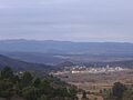
Sierra de Javalambre rising above Pina
|
|
| Highest point | |
| Elevation | 2,020 m (6,630 ft) |
| Listing | Mountains of Aragon, List of mountains in the Valencian Community |
| Geography | |

Sierra de Javalambre
Location in Spain
|
|
| Location | Gúdar-Javalambre, Aragon Rincón de Ademuz and Serrans, Valencian Community |
| Parent range | Iberian System, Eastern zone |
| Geology | |
| Mountain type | Karstic (Jurassic) |
| Climbing | |
| Easiest route | From the towns of La Puebla de Valverde, Ademuz or Riodeva |
The Sierra de Javalambre is a mountain range in Spain. It is about 29 kilometers (18 miles) long. You can find it in the Gúdar-Javalambre area of Aragon. It also stretches into the Rincón de Ademuz and Serrans areas of the Valencian Community.
A major road, N-234, goes between the Sierra de Javalambre and another mountain range called Serra d'Espadà. This road eventually reaches the coast at Sagunto.
Where is Sierra de Javalambre?
This mountain range is located at the eastern end of the Iberian System. The Sierra del Toro is a part of it that extends to the southeast. The highest point in the range is a peak also called Javalambre, which is 2,020 meters (6,627 feet) high.
Winter Snow and Skiing
The mountain tops here often get covered in snow during the winter. One of its peaks, Cerro Calderón (also known as Alto de las Barracas), is 1,839 meters (6,033 feet) high. It is the tallest peak in the Land of Valencia. There is also a small ski resort in the range called Aramón Javalambre. It has 12.2 kilometers (7.6 miles) of ski trails for winter sports fans.
Learn More
- List of mountains in Aragon
- Mountains of the Valencian Community
Images for kids
-
Sierra de Javalambre rising above Pina
See also
 In Spanish: Sierra de Javalambre para niños
