Signal Peak (Humboldt County, California) facts for kids
Quick facts for kids Signal Peak |
|
|---|---|

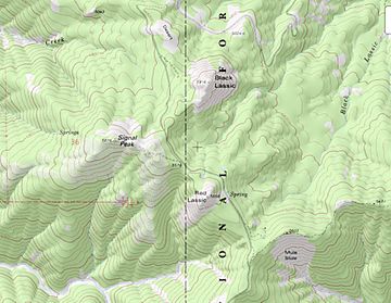
Topo map of Black Lassic
|
|
| Highest point | |
| Elevation | 5,880 ft (1,792 m) NAVD 88 |
| Prominence | 276 ft (80 m) |
| Geography | |
| Location | Humboldt County, California, U.S. |
| Topo map | USGS Black Lassic |
| Climbing | |
| Easiest route | Jeep Trail |
Signal Peak, also known as Mount Lassic, is a mountain in the Coast Range of Humboldt County, California. This peak was named after Lassic, an important Native American leader. He lived during a time of conflict called the Bald Hills War. There are two other mountains nearby, Red Lassic and Black Lassic, that also carry his name.
Contents
The Story Behind Signal Peak's Name
Why Was it Called Lassecks Peak?
The very first name for this mountain was "Lassecks Peak." This name appeared on an official map of the county in 1898. It was one way of spelling the name of Lassic, the Native American leader. Local people in the area knew the mountain by names like Lassek's Peak, Lassik's Peak, and Lassic Peak.
How Did Signal Peak Get Its Name?
The official name, Signal Peak, came about around the year 1900. At that time, a special communication station was set up on the peak. This station used a device called a heliograph. A heliograph uses mirrors to flash sunlight and send messages over long distances. It was a way to signal without wires!
Exploring Mount Lassic Wilderness
What is the Mount Lassic Wilderness?
Mount Lassic and the land around it are part of a special protected area. This area covers about 7,279 acres. It is located within the Six Rivers National Forest. In 2006, the United States Congress officially made it part of the National Wilderness Preservation System.
Who Manages This Wilderness Area?
The U.S. Forest Service takes care of the Mount Lassic Wilderness. Their job is to protect the natural environment and keep it wild. Signal Peak is the highest point within this beautiful wilderness area.
 | Misty Copeland |
 | Raven Wilkinson |
 | Debra Austin |
 | Aesha Ash |


