
Simpsons Gap facts for kids
Quick facts for kids Simpsons Gap |
|
|---|---|

Simpsons Gap in the West MacDonnell Ranges
|
|
| Location | Burt Plain, Northern Territory |
| Range | MacDonnell Ranges |
| Coordinates | 23°40′32″S 133°43′07″E / 23.675655°S 133.718561°E |

Location in Northern Territory
|
|
Simpsons Gap is a special place in the West MacDonnell Ranges in Australia's Northern Territory. The local Arrernte people call it Rungutjirpa. It is about 18 kilometres west of Alice Springs. You can find it along the famous Larapinta Trail.
This beautiful gap is full of different plants and animals. It is especially known for the black-footed rock-wallaby. Simpsons Gap also has a waterhole that always has water, which is very important for the wildlife.
Contents
What is Simpsons Gap?
Simpsons Gap is a natural opening or pass through the MacDonnell Ranges. These ranges are ancient mountains that stretch across the Northern Territory. The gap was formed over many years by water and wind. It creates a path through the rocky landscape.
Why is it important?
Simpsons Gap is important for several reasons. It is a home for unique wildlife. It also holds deep cultural meaning for the Arrernte people. The permanent waterhole makes it a vital spot for animals to drink. It is also a popular place for people to visit and enjoy nature.
History of Simpsons Gap
Simpsons Gap has a long and rich history. It has been a significant place for thousands of years.
Arrernte People and Rungutjirpa
The Arrernte people are the traditional owners of this land. They have lived in the Arrernte area for a very long time. For them, Simpsons Gap, or "Rungutjirpa," is a very important spiritual place. They have many stories and traditions connected to this area. It is a place where their ancestors walked and where important ceremonies took place.
European Discovery
In 1871, a surveyor named Gilbert Rotherdale McMinn visited Simpsons Gap. He was exploring the area to find the best route for the Australian Overland Telegraph Line. This telegraph line was a huge project. It aimed to connect Australia to the rest of the world by telegraph. McMinn's visit was part of this important historical effort.
Animals and Plants
Simpsons Gap is a great place to see Australian wildlife and plants. The permanent waterhole helps many different species to survive.
Amazing Animals
One of the most famous animals you might see here is the black-footed rock-wallaby. These small wallabies are very good at climbing rocks. They are often seen near the waterhole. Other animals like birds, reptiles, and even some types of frogs live here too. The waterhole acts like an oasis in the dry landscape.
Unique Plants
The plants around Simpsons Gap are also special. You can find many types of native trees and shrubs. These plants have adapted to live in the desert environment. Some of them include different kinds of gum trees and acacias. They provide food and shelter for the animals.
Visiting Simpsons Gap
Simpsons Gap is a popular spot for tourists and locals. It is a great place to experience the natural beauty of the West MacDonnell Ranges.

The Larapinta Trail
Simpsons Gap is an important stop on the Larapinta Trail. This famous walking track is over 223 kilometres long. It goes through the West MacDonnell Ranges. Section 1 of the Larapinta Trail starts at the Alice Springs Telegraph Station and finishes right here at Simpsons Gap. Many people enjoy walking this part of the trail.
Things to Do
When you visit Simpsons Gap, you can enjoy several activities:
- Walking: There are short walks to the waterhole and longer trails for more adventurous hikers.
- Wildlife Spotting: Keep an eye out for the black-footed rock-wallabies, especially early in the morning or late in the afternoon.
- Photography: The scenery is stunning, with red rocks and clear skies.
- Picnics: There are picnic areas where you can relax and enjoy the peaceful surroundings.
Images for kids
-
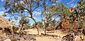
Leaving Simpsons Gap
-
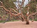
Gum at Simpsons Gap


