
Siret (river) facts for kids
Quick facts for kids Siret |
|
|---|---|

Siret River at Mircești
|
|

Path of the Siret [1]
|
|
| Country | Ukraine, Romania |
| Counties/ Oblasts |
Chernivtsi O., Botoșani C., Suceava C., Neamț C., Iași C., Bacău C., Vrancea C., Galați C. |
| Cities | Pașcani, Roman, Bacău, Galați |
| Physical characteristics | |
| Main source | Eastern Carpathians Chernivtsi O., Ukraine 1,238 m (4,062 ft) |
| River mouth | Danube Galați 45°24′11″N 28°1′27″E / 45.40306°N 28.02417°E |
| Length | 647 km (402 mi) |
| Basin features | |
| Progression | Danube→ Black Sea |
| Basin size | 44,811 km2 (17,302 sq mi) |
| Tributaries |
|
The Siret River is a long and important river in Eastern Europe. It starts high up in the Carpathian Mountains in Ukraine. From there, it flows south through Romania before joining the mighty Danube River.
The Siret River is about 647 kilometers (402 miles) long. Most of this length, about 559 kilometers (347 miles), is within Romania. The area of land that drains into the Siret River, called its drainage basin, covers about 44,811 square kilometers (17,302 square miles). This is a huge area, almost the size of Switzerland! On average, about 250 cubic meters (8,800 cubic feet) of water flow through the Siret every second. Long ago, in ancient times, people called this river Hierasus.
Contents
Where Does the Siret River Flow?
The Siret River passes by many towns and villages as it makes its way to the Danube. It starts in Ukraine and then flows through several counties in Romania.
Some of the towns and villages you would find along the Siret include:
- Berehomet
- Storozhynets
- Siret
- Grămești
- Zvoriștea
- Liteni
- Dolhasca
- Pașcani
- Stolniceni-Prăjescu
- Roman
- Bacău
- Adjud
- Mărășești
- Galați
Rivers Joining the Siret

Many smaller rivers flow into the Siret River along its journey. These are called tributaries. They add more water to the Siret, making it bigger and stronger.
Here are some of the rivers that join the Siret:
- From the Left Side: Bahna (Mihăileni), Molnița, Bahna (Lozna), Gârla Sirețel, Gârla Huțanilor, Vorona, Pleșul, Turbata, Pietrosul, Sirețel, Stolniceni, Hărmănești, Pârâul Țigăncilor, Mihăili, Boca, Albuia, Rediu, Vulpășești, Pârâul Pietros, Țiganca, Icușești, Glodeni, Râpaș, Moara, Bogdănești, Valea Morii, Ulm, Racova, Tamași, Răcătău, Soci, Fulgeriș, Rogoza, Polocin, Lupa, Bârlad, Călmățui, Geru, Bârlădel, Rusca, Mălina, Cătușa.
- From the Right Side: Malyi Seret, Găvan, Negostina, Pârâul Mare, Verehia, Baranca, Leahu, Stâncuța, Hănțești, Grigorești, Sălăgeni, Suceava, Șomuzul Mic, Șomuzul Mare, Pârâul lui Pulpa, Trestioara, Conțeasca, Ruja, Sodomeni, Valea Părului, Podul Turcului (Draga), Moldova, Valea Neagră, Turbata, Precista, Bistrița, Bahna, Valea Mare, Cleja (or Tocila), Răcăciuni, Drăgușeni, Scurta, Bolohan, Fântânele, Conțești, Trotuș, Valea Boului, Carecna, Câmpul, Zăbrăuț, Șușița, Gârla Morilor, Putna Seacă, Putna, Leica, Râmnicul Sărat, Buzău.
When the Siret River Floods
Rivers can sometimes overflow their banks, causing floods. This happened with the Siret River in July 2010. Heavy rains caused the water levels to rise very quickly.
On July 29, 2010, the Suceava County area was hit very hard. The Siret River almost broke through the protective walls, called dykes, near the town of Șendreni. Local people and emergency services worked together to make the dykes stronger. They used many truckloads of sandbags to stop the river from flooding the town.
Images for kids
-
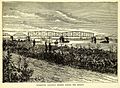
The former Barboși Railway Bridge, from an 1870s wood engraving

See also
- Global storm activity of 2010
- 2010 Romanian floods
 In Spanish: Río Siret para niños
