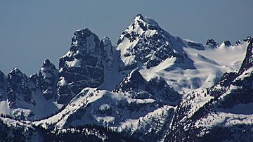
Sky Pilot Mountain (British Columbia) facts for kids
Quick facts for kids Sky Pilot Mountain |
|
|---|---|
 |
|
| Highest point | |
| Elevation | 2,031 m (6,663 ft) |
| Prominence | 1,236 m (4,055 ft) |
| Parent peak | Mamquam Mountain |
| Geography | |
| Location | British Columbia, Canada |
| Parent range | Britannia Range |
| Climbing | |
| Easiest route | South ridge |
Sky Pilot Mountain is a cool mountain located in British Columbia, Canada. It stands tall in the Britannia Range, which is part of the larger Coast Mountains. This mountain is named after a special boat called the Sky Pilot. This boat was a mission boat used by the United Church. There's also a place called Sky Pilot Rock near Desolation Sound that shares the same name.
Exploring Sky Pilot Mountain
Sky Pilot Mountain reaches an impressive height of 2,031 meters (about 6,663 feet) above sea level. It's a popular spot for adventurers and climbers. The easiest way to climb it is usually along its south ridge.
Where is Sky Pilot Mountain?
This mountain is found in the beautiful province of British Columbia, on the west coast of Canada. It's part of a mountain range known for its stunning views and rugged landscapes. The coordinates for Sky Pilot Mountain are 49°38′05″N 123°05′11″W.
Weather at the Mountain
The weather around Sky Pilot Mountain is mostly influenced by the Pacific Ocean. This area has what's called a marine west coast climate. This means it gets a lot of rain and snow, especially in winter.
Most of the weather comes from the Pacific Ocean. Big air masses, called weather fronts, move east towards the Coast Mountains. When these air masses hit the mountains, they are forced to rise. This process is called Orographic lift. As the air rises, it cools down and drops its moisture as rain or snow.
So, the Coast Mountains, including Sky Pilot, get a lot of precipitation. If you're planning to visit or climb Sky Pilot Mountain, the best time to go is usually from July through September. These months offer the clearest and most pleasant weather for outdoor activities.
 | Selma Burke |
 | Pauline Powell Burns |
 | Frederick J. Brown |
 | Robert Blackburn |


