
Skyline, Alabama facts for kids
Quick facts for kids
Skyline, Alabama
|
|
|---|---|

Skyline Town Hall
|
|

Location of Skyline in Jackson County, Alabama.
|
|
| Country | United States |
| State | Alabama |
| County | Jackson |
| Area | |
| • Total | 3.99 sq mi (10.34 km2) |
| • Land | 3.98 sq mi (10.31 km2) |
| • Water | 0.01 sq mi (0.03 km2) |
| Elevation | 1,591 ft (485 m) |
| Population
(2020)
|
|
| • Total | 834 |
| • Density | 209.50/sq mi (80.88/km2) |
| Time zone | UTC-6 (Central (CST)) |
| • Summer (DST) | UTC-5 (CDT) |
| Area code(s) | 256 |
| FIPS code | 01-70896 |
| GNIS feature ID | 0139288 |
Skyline is a small town located in Jackson County, Alabama, in the United States. It officially became a town in 1985. As of the 2020 census, about 834 people live there.
Contents
A Look Back: Skyline's History
Skyline started in 1934 as a special farming project. It was called "Cumberland Farms" at first. This project was part of a bigger plan by President Franklin Roosevelt to help people during tough economic times.
The Farming Experiment
The government program was called the Federal Emergency Relief Administration. Skyline Farms was one of 43 similar projects across the country. These projects aimed to help people in areas that were struggling. The name changed to "Skyline Farms" to avoid confusion with another project in nearby Tennessee. This farming experiment lasted for ten years. In 1944, the land was sold to private owners.
Where Skyline Is Today
The town of Skyline you see now is about one mile north of where the original farming community was located.
Geography: Where Skyline Is Located
Skyline is found at coordinates 34°48′11″N 86°7′25″W / 34.80306°N 86.12361°W. The town sits high up on the Cumberland Plateau. This is a large, flat area of land in western Jackson County.
Nearby Towns and Roads
- To the north of Skyline, you'll find the town of Hytop.
- To the southwest, there is Pleasant Groves.
- State Route 79 goes right through Skyline. This road connects the town to Scottsboro in the valley to the south. It also leads north into Tennessee.
- Another important road, State Route 146, meets SR 79 just north of Skyline. This route connects the area to the Paint Rock Valley to the west.
Size of the Town
According to the U.S. Census Bureau, Skyline covers a total area of about 3.9 square miles (10.3 square kilometers). All of this area is land.
Population and People of Skyline
The number of people living in Skyline has changed over the years. Here's a quick look at the population counts from different years:
| Historical population | |||
|---|---|---|---|
| Census | Pop. | %± | |
| 1990 | 740 | — | |
| 2000 | 843 | 13.9% | |
| 2010 | 851 | 0.9% | |
| 2020 | 834 | −2.0% | |
| U.S. Decennial Census 2013 Estimate |
|||
Skyline's Population in 2020
The 2020 United States census counted 834 people living in Skyline. There were 367 households and 258 families in the town.
| Race | Num. | Perc. |
|---|---|---|
| White (non-Hispanic) | 688 | 82.49% |
| Black or African American (non-Hispanic) | 3 | 0.36% |
| Native American | 27 | 3.24% |
| Other/Mixed | 69 | 8.27% |
| Hispanic or Latino | 47 | 5.64% |
Images for kids
-
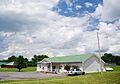
Skyline Town Hall
-
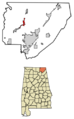
Location of Skyline in Jackson County, Alabama.
See also
 In Spanish: Skyline (Alabama) para niños
