Hytop, Alabama facts for kids
Quick facts for kids
Hytop, Alabama
|
|
|---|---|

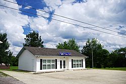
Hytop Town Hall
|
|

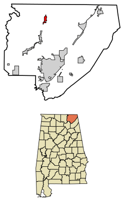
Location of Hytop in Jackson County, Alabama.
|
|
| Country | United States |
| State | Alabama |
| County | Jackson |
| Area | |
| • Total | 3.46 sq mi (8.97 km2) |
| • Land | 3.46 sq mi (8.96 km2) |
| • Water | 0.00 sq mi (0.01 km2) |
| Elevation | 1,709 ft (521 m) |
| Population
(2020)
|
|
| • Total | 441 |
| • Density | 127.46/sq mi (49.21/km2) |
| Time zone | UTC-6 (Central (CST)) |
| • Summer (DST) | UTC-5 (CDT) |
| ZIP code |
35768
|
| Area code(s) | 256 |
| FIPS code | 01-37264 |
| GNIS feature ID | 0156510 |
| Website | https://townofhytop.com/ |
Hytop is a small town in Jackson County, Alabama, United States. It officially became a town on May 17, 1991. According to the 2020 census, 441 people live there.
Just north of Hytop, you can find The Walls of Jericho. This is a very popular place for hiking and exploring nature.
Discover Hytop's Location
Hytop is located at 34°54′17″N 86°5′12″W / 34.90472°N 86.08667°W. This means it's in the northern part of Alabama. The town sits high up on a large flat area called the Cumberland Plateau. This plateau stretches across several states.
Hytop is very close to the border between Alabama and Tennessee. A road called State Route 79 goes right through Hytop. This road connects the town to Skyline to the south. If you go north on this road, it turns into Tennessee State Route 16 when you cross into Tennessee. It then continues to Winchester, Tennessee.
West of Hytop, there's a narrow valley. It was carved out by a stream called Hurricane Creek. This creek flows into the Paint Rock River. The famous Walls of Jericho are also found near the top of this valley, right at the state line.
The U.S. Census Bureau says that Hytop covers about 3.46 square miles (8.96 square kilometers) of land.
Hytop's Growing Population
| Historical population | |||
|---|---|---|---|
| Census | Pop. | %± | |
| 2000 | 315 | — | |
| 2010 | 354 | 12.4% | |
| 2020 | 441 | 24.6% | |
| U.S. Decennial Census | |||
Every ten years, the United States counts its population in a survey called the census. In 2000, 315 people lived in Hytop. By 2010, the population had grown to 354. The most recent count in 2020 showed that 441 people now call Hytop home.
In 2000, there were 124 homes in Hytop. Most of these homes were families living together. The people in Hytop come from different backgrounds, with most being White. A small number of residents were Native American or from two or more races.
The average age of people in Hytop in 2000 was 35 years old. This means about half the people were younger than 35 and half were older.
Weather Radar Site
The National Weather Service has a special radar site located in Hytop. This radar helps meteorologists track storms and predict the weather. It was damaged during a very strong storm event in 2011, known as the Super Outbreak. However, it was later fixed and replaced to continue its important work.
See also
 In Spanish: Hytop para niños
 | Anna J. Cooper |
 | Mary McLeod Bethune |
 | Lillie Mae Bradford |

