
Slanting Peak facts for kids
Quick facts for kids Slanting Peak |
|
|---|---|

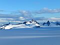
Aerial view of north aspect, with Norris Glacier
|
|
| Highest point | |
| Elevation | 5,200+ ft (1,580+ m) |
| Prominence | 1,600 ft (490 m) |
| Isolation | 5.53 mi (8.90 km) |
| Parent peak | Amherst Peak |
| Geography | |

Slanting Peak
Location in Alaska
|
|
| Location | Tongass National Forest Juneau Borough Alaska, United States |
| Parent range | Coast Mountains Boundary Ranges Juneau Icefield |
| Topo map | USGS Juneau C-1 |
Slanting Peak is a tall, icy mountain in Alaska, United States. It stands about 5,200+ ft (1,580+ m) high. This peak is part of the Boundary Ranges within the larger Coast Mountains.
You can find Slanting Peak in the southern part of the Juneau Icefield. It's located about 18 mi (29 km) northeast of the city of Juneau. Its closest neighbor is Guardian Mountain, which is about 2.4 mi (4 km) away to the northeast.
Slanting Peak is surrounded by huge glaciers. The North Branch Norris Glacier is to its west, and the massive Taku Glacier is to its east. The land around the peak is managed by the Tongass National Forest. The name "Slanting Peak" was officially given to this mountain in 1960 by the U.S. Geological Survey.
Contents
What is the Climate Like at Slanting Peak?
Slanting Peak is in a subarctic climate zone. This means it has very long, cold, and snowy winters. The summers are usually cool.
How Does Weather Affect the Mountain?
Weather systems from the Gulf of Alaska hit the Coast Mountains. The mountains force the air upwards, which is called orographic lift. This causes a lot of rain and snow to fall on the peak.
What Are the Temperatures Like?
Temperatures at Slanting Peak can get very cold, sometimes dropping below −20 °C. With the wind, it can feel even colder, below −30 °C. If you want to see or climb Slanting Peak, July usually has the best weather.
Images for kids
-
Slanting Peak centered, with Guardian Mountain to right

