Slatedale, Pennsylvania facts for kids
Quick facts for kids
Slatedale, Pennsylvania
|
|
|---|---|

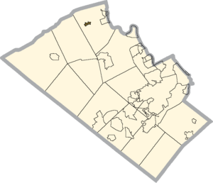
Location of Slatedale in Lehigh County, Pennsylvania
|
|
| Country | |
| State | |
| County | Lehigh |
| Township | Washington |
| Area | |
| • Census-designated place | 0.77 km2 (0.30 sq mi) |
| • Land | 0.77 km2 (0.30 sq mi) |
| • Water | 0.0 km2 (0 sq mi) |
| Elevation | 153 m (501 ft) |
| Population
(2010)
|
|
| • Census-designated place | 455 |
| • Density | 590.0/km2 (1,528/sq mi) |
| • Metro | 865,310 (US: 68th) |
| Time zone | UTC-5 (Eastern (EST)) |
| • Summer (DST) | UTC-4 (EDT) |
| ZIP Codes |
18079, 18080
|
| Area code(s) | 610 and 484 |
| FIPS code | 42-71080 |
| GNIS feature ID | 1187788 |
Slatedale is a small community in Lehigh County, Pennsylvania. It is known as an unincorporated community and a census-designated place (CDP). This means it's a recognized area, but it doesn't have its own local government like a city or town. Instead, it's part of Washington Township.
In 2010, about 455 people lived in Slatedale. It's part of a larger area called the Lehigh Valley. This valley is home to many people and is a busy part of the United States.
Where is Slatedale?
Slatedale is located in the northern part of Lehigh County. It sits west of the center of Washington Township. If you travel about 3 miles (4.8 km) east, you'll find the borough of Slatington. The city of Allentown is about 16 miles (26 km) northwest. Allentown is the main city in Lehigh County.
Both Slatedale and Slatington got their names because of the large amounts of slate rock found nearby. Slate is a type of rock often used for roofing and other building materials.
Land and Water Features
The community covers an area of about 0.8 square kilometers (0.3 square miles). Most of this area is land. A small part, about 0.32%, is water.
A stream called Trout Creek forms the southern edge of Slatedale. This creek flows east and eventually joins the Lehigh River in Slatington. To the north, about 2 miles (3.2 km) away, you can see Blue Mountain. This mountain is a part of the larger Appalachian mountain range.
Community Services
The people of Slatedale have important services to keep them safe and connected. The Citizen's Fire Co #1 in Slatedale provides fire protection. For medical emergencies, Northern Valley EMS offers ambulance services.
Slatedale has its own post office with the ZIP Code 18079. However, some areas nearby use the Slatington ZIP Code, which is 18080.
Population Changes
The number of people living in Slatedale has changed over time.
- In 2000, the population was 389 people.
- By 2010, the population had grown to 455 people.
See also
 In Spanish: Slatedale para niños
 | Bayard Rustin |
 | Jeannette Carter |
 | Jeremiah A. Brown |


