Sloan, New York facts for kids
Quick facts for kids
Sloan
|
|
|---|---|
| Village of Sloan | |

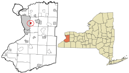
Where Sloan is located in Erie County and the state of New York
|
|
| Country | United States |
| State | New York |
| County | Erie |
| Town | Cheektowaga |
| Area | |
| • Total | 0.79 sq mi (2.04 km2) |
| • Land | 0.78 sq mi (2.02 km2) |
| • Water | 0.01 sq mi (0.02 km2) |
| Elevation | 614 ft (187 m) |
| Population
(2020)
|
|
| • Total | 3,775 |
| • Density | 4,839.74/sq mi (1,868.69/km2) |
| Time zone | UTC-5 (Eastern (EST)) |
| • Summer (DST) | UTC-4 (EDT) |
| ZIP code |
14212
|
| Area code(s) | 716 |
| FIPS code | 36-67686 |
| GNIS feature ID | 0965429 |
Sloan is a small village located in Erie County, New York, in the United States. In 2020, about 3,775 people lived there. Sloan is part of the larger Buffalo–Niagara Falls area. It is also found within the town of Cheektowaga.
History of Sloan
When was Sloan founded?
The village of Sloan was officially started in 1896. It was formed from a part of the nearby town of Cheektowaga.
Sloan's Railroad Past
Sloan has always been important for railroads. It is located between two big train yards: the CSX Frontier yard to the north and the Norfolk Southern Bison yard to the south. These yards were once known as the New York Central and Erie-Lackawanna yards. Because of these yards, Sloan was a key railroad town, much like Depew.
Police Services in Sloan
For many years, Sloan had its own police department. This police force usually had between three and six officers. Around 1978, the village's police force was ended. The officers joined the Cheektowaga Police Department. Today, the Cheektowaga Police Department still provides police services for Sloan.
Local Businesses
Did you know that Visniak brand soft drinks used to be made right here in Sloan?
Famous People from Sloan
Some well-known people have connections to Sloan:
- Jerry Augustyniak: He is the drummer for the famous band 10,000 Maniacs.
- Edmund P. Radwan: He was a former member of the U.S. Congress.
Geography of Sloan
Where is Sloan located?
Sloan is located at coordinates 42.894458 degrees north and -78.791353 degrees west. When the village was first established, the land owned by Sam Sloan extended to the New York State Thruway. Today, the village covers about 0.8 square miles (2.04 square kilometers).
What are Sloan's boundaries?
The village has clear boundaries. To the north, it is bordered by New York State Route 130, which is also known as Broadway. To the east, Sloan is bordered by New York State Route 240, also called Harlem Road.
Population of Sloan
How many people live in Sloan?
The population of Sloan has changed over the years. Here's a look at how many people have lived in the village:
| Historical population | |||
|---|---|---|---|
| Census | Pop. | %± | |
| 1900 | 873 | — | |
| 1910 | 1,259 | 44.2% | |
| 1920 | 1,791 | 42.3% | |
| 1930 | 3,482 | 94.4% | |
| 1940 | 3,836 | 10.2% | |
| 1950 | 4,698 | 22.5% | |
| 1960 | 5,803 | 23.5% | |
| 1970 | 5,216 | −10.1% | |
| 1980 | 5,529 | 6.0% | |
| 1990 | 5,830 | 5.4% | |
| 2000 | 6,775 | 16.2% | |
| 2010 | 7,532 | 11.2% | |
| 2020 | 3,775 | −49.9% | |
| U.S. Decennial Census | |||
In 2000, there were 3,775 people living in Sloan. There were 1,680 households and 1,033 families. The village had about 4,755.6 people per square mile.
What is the age range of Sloan's residents?
In 2000, about 20.1% of the people in Sloan were under 18 years old. About 24.2% of the population was 65 years old or older. The average age in the village was 42 years.
See also
 In Spanish: Sloan (Nueva York) para niños
 | Roy Wilkins |
 | John Lewis |
 | Linda Carol Brown |

