
Slocan Lake facts for kids
Quick facts for kids Slocan Lake |
|
|---|---|

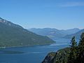
as seen from Bannock Point
|
|

Slocan Lake
Location in British Columbia
|
|
| Location | Slocan Country, West Kootenay, British Columbia |
| Coordinates | 49°57′N 117°23′W / 49.950°N 117.383°W |
| Primary inflows | Bonanza Creek, Wilson Creek, Carpenter Creek, Seaton Creek |
| Primary outflows | Slocan River |
| Catchment area | Kootenay River |
| Basin countries | Canada |
| Max. length | 39 km (24 mi) |
| Max. width | 2.7 km (1.7 mi) |
| Surface area | 69.29 km2 (26.75 sq mi) |
| Average depth | 171 m (561 ft) |
| Max. depth | 298 m (978 ft) |
| Water volume | 5.7 cubic kilometres (1.4 cu mi) |
| Shore length1 | 84.1 kilometres (52.3 mi) |
| Surface elevation | 542 m (1,778 ft) |
| Settlements | Slocan City, New Denver, Silverton, Rosebery, Hills |
| 1 Shore length is not a well-defined measure. | |
Slocan Lake is a beautiful lake in the Slocan Valley of British Columbia, Canada. It is part of the West Kootenay region. The lake gets its water from streams like Bonanza Creek. The Slocan River flows out of the lake. This river travels south from Slocan City. It eventually joins the Kootenay River, which then flows into the Columbia River.
Contents
Slocan Lake: A Gem in British Columbia
Slocan Lake is a long, narrow lake. It stretches for about 39 kilometers (24 miles). The lake is also quite deep, reaching a maximum depth of 298 meters (978 feet). This makes it one of the deeper lakes in the area. Its clear waters are a popular spot for many activities.
Where is Slocan Lake?
Slocan Lake is located in the southeastern part of British Columbia. It sits within the Slocan Valley. To the west of the lake, you can see the stunning Valhalla Provincial Park. This park protects a large part of the Valhalla Range mountains.
Towns and Parks Around the Lake
Several towns and communities are found along the shores of Slocan Lake. Slocan City is at the southern end. It is often called "Slocan City" to tell it apart from other nearby places. Further north, on the eastern side, are the towns of New Denver and Silverton.
Even further north, you will find Rosebery. This community is located where Wilson Creek flows into the lake. At the very northern tip of Slocan Lake is a small place called Hills. These communities offer great places to live and visit.
A Look Back: The Silver Rush Era
The mountains east of Slocan Lake were once very important. They were the center of a "silver rush" known as "the Silvery Slocan." This was a time when many people came looking for silver. Steamboats and railways were built to reach the mining areas.
How Silver Changed the Area
The town of Sandon became the main hub of the silver rush. Three different railways connected to Sandon. Two came from the Slocan Lake area. The third came from Kaslo on Kootenay Lake. In 1902, zinc was also discovered. This discovery added to the excitement in the region.
Getting Around Slocan Lake
Today, you can drive along the eastern shore of Slocan Lake. BC Highway 6 follows the lake from Hills to Slocan City. From Slocan City, the highway continues down the Slocan River. A Canadian Pacific rail line also runs near the lake. It used to go all the way to Sandon. Now, it stops at Rosebery Slip on Slocan Lake.
Gallery
-
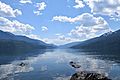
Slocan Lake in British Columbia
-
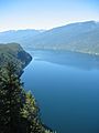
Another view of Slocan Lake
-
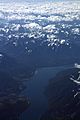
A wide view of Slocan Lake
-
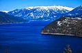
Slocan Lake with mountains in the background
-
General view of Slocan Lake
-
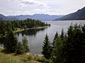
Slocan Lake near Rosebery
-
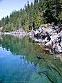
Clear water near Molly Hughes mine
_BC.jpg)
_BC_07-2004.jpg)
.jpg)
.jpg)


