
Slocan Valley facts for kids
Quick facts for kids Slocan Valley |
|
|---|---|
.jpg)
|
|

Location in British Columbia
|
|
| Location | Kootenays, British Columbia, Canada |
| Coordinates | 49°41′00″N 117°30′09″W / 49.6834°N 117.5024°W |
The Slocan Valley is a beautiful valley located in the West Kootenay region of southeastern British Columbia, Canada. It's a long, narrow area nestled between mountain ranges.
Contents
- What is the Slocan Valley?
- Who lived in the Slocan Valley first?
- What was the mining boom?
- How did people travel and farm?
- What was Japanese internment?
- How did the valley change in the 1970s?
- Why do people move to the Slocan Valley today?
- What can you do for fun in the Slocan Valley?
- Images for kids
What is the Slocan Valley?
The Slocan Valley stretches for about 100 kilometers (62 miles). It is bordered by the steep Valhalla Range to the west and the gentler Slocan Range to the east. In the north, you'll find Slocan Lake, and in the south, the Slocan River flows through.
This valley is part of a larger geological area called the Kootenay Arc. This arc is about 400 kilometers (250 miles) long. The rocks here, including sedimentary, volcanic, and metamorphic rock, were formed around 200 million years ago during the Jurassic period.
The name "Slocan valley" was first used in records in 1891. The word slocan comes from a local First Nations word meaning "pierce" or "strike on the head." This refers to how salmon were traditionally caught using harpoons.
Where are the Slocan Valley's borders?
The exact boundaries of the Slocan Valley can be a bit tricky to define. Generally, it includes the area from Crescent Valley in the south up to Hills in the north. It might also stretch east to Retallack.
Some places that are sometimes considered part of the valley, but not always, include South Slocan, Krestova, Pass Creek, and Summit Lake. Shoreacres, which is at the mouth of the Slocan River, is usually not included.
The valley is definitely home to several villages and communities:
- The villages of Slocan, Silverton, and New Denver.
- Unincorporated communities like Crescent Valley, Slocan Park, Passmore, Vallican, Winlaw, Appledale, Perry Siding, Lemon Creek, Rosebery, and Hills.
On the western side of the upper valley, you'll find Valhalla Provincial Park. East of Slocan Lake, there are old mining ghost towns such as Sandon, Cody, and Three Forks.
Who lived in the Slocan Valley first?
The Sinixt and Ktunaxa First Nations peoples have lived in the Slocan Valley for thousands of years. They built camps and burial grounds, especially in the southern parts of the valley. Some areas are still part of ongoing discussions about land treaties.
What was the mining boom?
The northern part of the valley experienced a big mining boom in the early 1890s. This happened after rich silver-lead ore was discovered near Sandon. Thousands of prospectors came to the valley hoping to find their fortune.
Many small settlements quickly grew along what is now Highway 31A, which connects New Denver and Kaslo. However, by 1910, many of these settlements were empty and eventually disappeared. Some larger silver mines continued to operate until the 1980s.
How did people travel and farm?
The Canadian Pacific Railway once had two railway lines in the valley. These lines were connected by a ferry that crossed Slocan Lake, helping people and goods move around.
Farming and the Doukhobors
Like the First Nations before them, early settlers realized that the lower valley had very fertile land perfect for farming. A group called the Doukhobors were among the most important early farmers. They settled in Brilliant in 1908, and their communities spread to the south end of the valley. Many of their descendants still live there today.
Today, many small private farms, some started by the Doukhobors, grow organic fruits and vegetables. These fresh products are sold at local farmer's markets, to restaurants, grocery stores, and food companies.
British orchardists
In the 1910s, British immigrants came to the valley with a dream of starting small commercial fruit orchards, especially for apples. However, the climate and often steep land made it difficult for these orchards to succeed. Today, only a few of those original orchards remain.
What was Japanese internment?
During World War II, several internment centers were set up in the West Kootenay region. Thousands of Japanese Canadians were forced to move from the coast of British Columbia to these camps. In the Slocan Valley, these camps were located from Lemon Creek in the south to Rosebery in the north, and Sandon in the east. Many Japanese Canadians decided to stay in the valley even after the war ended.
How did the valley change in the 1970s?
The "back-to-the-land movement" was popular in the 1970s. Many people, including hippies and Americans who avoided the Vietnam War, moved to the Slocan Valley. They wanted to live simply, often in communal groups, and grow their own food.
While not everyone found this lifestyle easy, many who stayed became skilled artisans. They developed talents in theatre, writing, painting, ceramics, and textiles. Some people in the valley still choose to live off grid (without being connected to public utilities) or in a commune (a community where people share resources). You can find locally made natural soaps, wellness products, and clothing sold online. The valley is also home to a team of talented ice and sand sculptors.
Why do people move to the Slocan Valley today?
Since the mid-1960s, people from cities have been drawn to the Slocan Valley. They like the rural lifestyle and the lower cost of living. With better cell service and internet, many residents can now work from home. By 2023, high-speed internet through a fiber optic network made working remotely even easier. Many residents also travel daily to larger towns like Nelson, Castlegar, and Nakusp.
What can you do for fun in the Slocan Valley?
The Slocan Valley offers many fun activities for visitors. Popular things to do include:
- Mountain biking
- Rafting on the Slocan River
- Backcountry skiing
- Rock climbing at the Slocan Bluffs
- Visiting Valhalla Provincial Park
Golf games are also much cheaper here than in bigger cities. Many independent tourism companies help people enjoy these activities.
You can find giant cedar trees in small areas throughout the valley. One easy-to-reach spot is the Retallack Old Growth Cedar Trail. While timber harvesting (cutting down trees for wood) was once a major part of the economy, the focus has shifted to other activities.
Images for kids
-
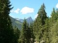
Sacred to Sinixt people, Frog Mountain, Slocan Valley.
-
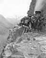
K&SR, Payne Bluff above Sandon, c.1910.
-
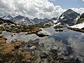
Gregorio Peak, Valhalla Provincial Park, 2012.

.jpg)

