Smith River State Recreational Waterway facts for kids
Quick facts for kids Smith River State Recreational Waterway |
|
|---|---|
|
IUCN Category V (Protected Landscape/Seascape)
|
|

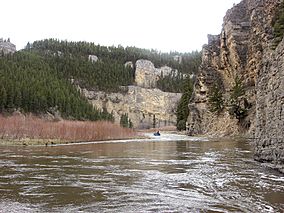
Floating the Smith River in April 2010.
|
|
| Location | Meagher County and Cascade County, Montana, U.S. |
| Nearest city | Ulm, Montana (Eden Bridge end); White Sulphur Springs, Montana (Camp Baker end) |
| Area | 58.9 miles (94.8 km) (river length); 51 acres (0.21 km2) (Camp Baker); 4.47 acres (0.0181 km2) (Eden Bridge); 797 acres (3.23 km2) (Smith River corridor land) |
| Visitors | 6,106 (in 2023) |
| Governing body | Montana Department of Fish, Wildlife and Parks |
The Smith River State Recreational Waterway, often called the Smith River State Park, is a special river area in Montana, USA. It's not a regular state park, but a "virtual park" managed by the state. This means the state owns the Smith River itself, plus key access points like Camp Baker and Eden Bridge. It also manages 27 boat camps along the river.
Most of the land around the river is owned by other groups, like the United States Forest Service, United States Bureau of Land Management, and private citizens. However, the state works with these owners to manage the 58.9-mile (94.8 km) Smith River area. The Smith River is the only river in Montana where you need a permit to boat or float.
Contents
- Exploring the Smith River's Journey
- How the Smith River Became a Special Place
- Managing the River: 1970s to 1980s
- Growing Popularity and New Rules: 1980s to 1990s
- Managing the River: 1990s and Beyond
- Challenges and Changes: 1996 to 2009
- New Rules and Future Plans (2009)
- Recent Management and Challenges
- About the Smith River Waterway
Exploring the Smith River's Journey
The Smith River is about 110-mile (180 km) long. It starts near White Sulphur Springs, Montana, and flows north. The river passes between the Big Belt Mountains and Little Belt Mountains. Finally, it joins the Missouri River at Ulm, Montana.
The river has three main parts. The first part is about 25 miles (40 km) long. It flows through a high valley between two mountain ranges. The second part is about 58.8 miles (94.6 km) long. This section goes through the beautiful Smith River Canyon Valley. The third part is about 30 miles (48 km) long. It starts at the end of the canyon and flows into the Missouri River. This last part slows down as it reaches the Great Plains.
The river is usually too shallow for motorboats. The best time for boating is from mid-April to early July. After July, the water levels often get too low for floating.
How the Smith River Became a Special Place
For a long time, it was hard for people to get to the Smith River. This was because there were few roads and most of the land was privately owned. In the late 1950s, people started using the river for fishing and floating. As more people wanted to visit, problems started with private landowners.
The state of Montana decided to help. In 1953, people suggested turning state-owned land along the river into recreation areas. The Montana Department of Fish and Game (DFG) supported this idea.
Early Steps to Public Access
In 1960, the DFG bought a place now called the Smith River Fishing Access. More people started using the river in the 1960s. This led to safety concerns and more conflicts between landowners and the public. To create a new public spot, the DFG bought the 51-acre (0.21 km2) Camp Baker Fishing Access Site in 1968. This site allowed people to launch their boats.
In 1969, the Montana Fish and Game Commission made the Smith River a State Recreational Waterway. This decision stopped motorized boats on the river. The state government then studied the river to see how it could be used for recreation. They decided to manage the river as a State Recreational Waterway. They also found that the Smith River was a navigable waterway. This meant the water and riverbed belonged to the state, giving the state the right to manage it for public use.
Managing the River: 1970s to 1980s
By 1970, most of the Smith River Canyon shoreline was privately owned. The DFG started to see more people using the river. This led to more conflicts. Problems included litter, trespassing, and how to deal with human waste. The DFG tried to buy more land for public access, but it was hard to find the money.
In 1973, the DFG studied the river's natural resources. They suggested new laws to protect the river. They also wanted more money to buy land along the river. By the mid-1970s, water levels were often too low for boating in summer. This was due to melting snow and water used for irrigation. The DFG also changed its plan for fish. They decided to focus on managing wild trout instead of stocking non-native fish.
Growing Popularity and New Rules: 1980s to 1990s
In 1980, the Montana Department of Fish, Wildlife and Parks (FWP) started managing the Smith River more closely. They installed signs and set up the first boat camps. At first, FWP wanted to limit how many people used the river. This was to keep the river wild and give people privacy.
However, more people started to discover the Smith River. In 1981, FWP asked users to register voluntarily. They also hired a river ranger, the first in Montana. In 1982, FWP leased land at Eden Bridge as a "take-out point" for boats. A shuttle service was added in 1983, making it easier for floaters. FWP also gained more land, adding 13 new areas for public use.
Understanding How Many People Use the River
The number of people using the Smith River grew even more after articles and advertisements featured it. FWP started sending game wardens to fine people who broke rules. In 1984, FWP formed a group called "Concerned Citizens of the Smith River Canyon." This group helped solve problems and advised FWP.
In 1985, the Montana Stream Access Law opened all navigable rivers in Montana to public use. This led to even more people visiting the Smith River. By 1986, the river was so popular that the state asked users to tell them when they used the river. FWP also leased more land for boat camps.
The Shouse Study and Carrying Capacity
In 1986, FWP released a report about public use of the river. It was done by a consultant named Joel Shouse. The study found that when more than 100 floaters were on the river each day, people felt it was too crowded. This was called the "carrying capacity" of the river.
Shouse suggested five steps to control how many people used the river:
- Step 1: Keep doing surveys and voluntary registration. Ask users which boat camps they plan to use.
- Step 2: Make registration mandatory. Everyone needs a permit attached to their boat.
- Step 3: Limit the number of permits during the busiest times (late May to early July).
- Step 4: Limit the number of permits issued each day of the floating season.
- Step 5: Use a lottery system for permits if too many people want to go.
Step 1 was put into action in 1987.
The 1988 Management Plan and New Laws
In 1988, FWP released the "Smith River Management Plan." This plan used Shouse's ideas. It set a limit of 15 float parties per day. A float party could have up to 15 people.
To make more rules, the Montana State Legislature passed the Smith River Management Act in 1989. This law allowed FWP to make rules for the river. It said FWP must keep the river open for recreation, protect its beauty, and save its natural values. The law also allowed FWP to charge fees for using the river.
Managing the River: 1990s and Beyond
In 1990, FWP started Step 2 of its plan: mandatory permits. Every group had to get a permit at Camp Baker and attach it to their boat.
Group Limits and User Fees (1991)
When the number of floaters kept rising, FWP started Step 3 in 1991. They limited groups to 15 people. Everyone also had to say which boat camps they would use. FWP also started charging fees for permits. These were the first user fees for a state-managed river in Montana. The money from these fees helped FWP hire a second river ranger.
By mid-1991, the number of users was still growing. This led FWP to start Step 4. They began a "lottery" for permits on busy days. They also limited commercial boat launches and the number of outfitters. In 1992, FWP added electricity and running water to Camp Baker and Eden Bridge. They also created a "Corridor Enhancement Account" to save money for protecting the river.
Launch Limits (1993)
In 1993, FWP implemented Step 5 of its plan. All users now had to register ahead of time for a permit. The total number of launches per day was limited to nine. The number of approved outfitters was also lowered. The Smith River became one of the few rivers in the country with launch limits.
The river's popularity meant FWP's budget for managing it grew a lot. More people were calling about permits, and many permits were canceled last minute. In 1993, FWP also changed how fees went into the Corridor Enhancement Account.
New Management Plan (1996)
By 1993, the number of users had increased by 246.5% since 1988. In 1994, user fees were high enough for FWP to buy the Eden Bridge take-out site. FWP now managed several access sites and 27 boat camps.
In 1996, FWP updated its management plan. It set new limits on group size and the number of launches. The plan also required FWP to create a "protection strategy" for private lands next to the river.
Challenges and Changes: 1996 to 2009
The number of users continued to grow, reaching an all-time high of 4,771 in 1997. In 1998, FWP changed its permit cancellation policy. They stopped reissuing canceled permits on very busy weeks. This helped reduce the total number of users for a few years.
By 2003, the environment around the river was showing signs of wear. Firewood was scarce. Boat camps got steel fire rings to reduce impact on forests and prevent large fires. FWP also changed its cancellation policy again to encourage smaller groups.
In 2005, a new law said that user fees must be used for specific things. These included protecting the river, improving fish habitats, and keeping water flowing. In 2006, FWP made new rules for commercial activities on restricted rivers. In 2007, FWP built a new office and house at Camp Baker for its growing staff of park rangers. They also updated the Smith River Management Plan and created a new Citizen's Advisory Council.
New Rules and Future Plans (2009)
In 2009, FWP released a new management plan for the next 10 to 15 years. This plan used a new idea called "Limits of Acceptable Change." This means focusing on what conditions they want for the river, rather than just how many people it can handle.
The new plan kept the existing limits on launches per day and group size. It also added a new way to measure "solitude" by asking floaters how satisfied they were with the number of other boats they saw. The number of outfitters was reduced from 16 to nine.
A study also found that the Smith River Corridor Enhancement Account had a lot of money, but none of it had been spent. The new rule required FWP to create rules for spending this money. The plan also aimed to buy or lease land for new, isolated boat camps to improve solitude.
The study also found environmental problems. Human waste was causing high levels of bacteria in the river. FWP started thinking about requiring floaters to pack out their human waste.
Recent Management and Challenges
The Smith River's popularity kept growing. Permit applications reached an all-time high of 9,365 in 2015.
New Permit System and Fish Restoration
In 2010, FWP considered new rules. One idea was to make people wait a year before applying for another permit if they got one. Another was to require packing out human waste at a new boat camp. A new "super permit" lottery was also proposed. For $5, people could buy unlimited chances to win a permit for any day. Most of these rules were approved, and the Super Permit lottery started in 2013.
In 2010, FWP also started a plan to bring back westslope cutthroat trout to the river. This involved removing other trout species and then introducing cutthroat. By 2014, there were five groups of these native trout in the river area.
Dealing with Bears
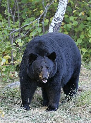
In 2012, FWP started thinking about requiring bear-proof food storage. This was because black bears were getting used to finding food near humans. In July 2013, the river was closed for six days after black bears entered boat camps. Eight bears were captured and moved.
FWP didn't immediately require bear-proof containers. Instead, they bought food storage boxes for some camps and told floaters how to avoid bear problems. But bear activity continued. By the end of 2015, FWP started making rules for mandatory bear-proof food and waste storage. These rules began in the 2016 float season.
Money for River Improvements
By 2011, little money from the Corridor Enhancement Account (CEA) had been spent. In 2012, FWP approved projects to stabilize river banks and improve fish habitat using CEA funds.
In 2013, a group called Trout Unlimited found that FWP had used CEA money for things like a storage building and road maintenance. They argued this was not allowed by the law. FWP agreed to repay some of the money to the CEA fund. By late 2016, the CEA had over $400,000.
In 2014, a Montana artist named Monte Dolack painted the Smith River to celebrate the state park system's 75th anniversary. Prints of his painting were sold to raise money for state parks.
Mining Concerns and Fish Research
In 2012, a mining company wanted to open a copper mine near the Smith River's headwaters. Environmental groups and sportsmen strongly opposed this. They worried the mine could pollute the river. Because of this, American Rivers, a clean water group, named the Smith River one of "America's Ten Most Endangered Rivers" in 2015 and 2016.
Since 2010, FWP has been working with Montana State University to study the river's fish. They use "pit tags" to track fish movement. This research helps FWP understand where fish gather and which streams need more protection.
About the Smith River Waterway
The Smith River is a State Recreational Waterway, not a traditional state park. It's more like a special management program for the river. However, FWP often calls it the "Smith River State Park."
Between Camp Baker and Eden Bridge, parts of the river's shore are owned by the Lewis & Clark National Forest and the Helena National Forest. The Montana Department of Natural Resources and Conservation also owns some land. FWP works with these groups to manage the river.
Permits for Floating
The Smith River is the only river in Montana where a permit is required to boat. FWP holds a lottery each winter to give out about 1,000 permits. Float parties can have up to 15 people, and only nine launches are allowed each day. FWP also has a "Super Permit" lottery. People can buy many tickets to try and win a permit for any day they choose.
Starting Points, Camps, and Exits
FWP owns about 797 acres (3.23 km2) of land along the river. The state also owns the riverbed and manages the river's waters.
Camp Baker is the only place to launch boats. It has a house for staff, a ranger station, a storage building, an information kiosk, restrooms, parking, and boat ramps. It also has a camping area with picnic tables and fire grates. Most of the riverbanks are privately owned, so public access is limited. However, some trails and private roads offer limited access.
There are 52 public boat camps between Camp Baker and Eden Bridge. Each camp has places to tie up boats, a fire ring, and a restroom. These camps are on land owned by the USFS, FWP, or private landowners who lease their land to FWP.
Eden Bridge is the only place to take boats out of the river. It has a boat take-out area, a restroom, a storage shed, and a hardened area with electricity for volunteer hosts. There are also three campsites, but overnight camping is not allowed for most visitors during the busy season.
What You'll See in the Smith River Canyon
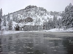
The Smith River Recreational Waterway flows through the Smith Canyon, which is about 1,000-foot (300 m) deep. The rocks in the canyon are very old, showing different periods of Earth's history. You can see interesting rock formations like folds and faults.
The Smith River is a great place for fishing. You can catch fish like brown trout, rainbow trout, and whitefish. Other fish include brook trout, burbot, and cutthroat trout.
Many animals live in the Smith River canyon, including black bears, cougars, elk, and different types of deer and grouse. Hunting is allowed on state and federal lands during certain seasons.
The canyon also has many cultural sites from Native American history. These include old campsites with tipi rings and "rock art" sites with pictographs. These pictographs are drawings on rocks, some as old as 1,200 to 1,400 years. Many of these sites are on private land and are considered sacred. It's against the law to touch, change, or damage these cultural sites.
 | Anna J. Cooper |
 | Mary McLeod Bethune |
 | Lillie Mae Bradford |


