Smithville, Tennessee facts for kids
Quick facts for kids
Smithville, Tennessee
|
|
|---|---|

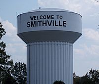
Smithville Watertower
|
|

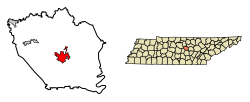
Location of Smithville in DeKalb County, Tennessee.
|
|
| Country | United States |
| State | Tennessee |
| County | DeKalb |
| Founded | 1838 |
| Incorporated | 1843 |
| Named for | Samuel Granville Smith, local politician |
| Government | |
| • Type | Mayor-Aldermanic |
| Area | |
| • Total | 5.85 sq mi (15.16 km2) |
| • Land | 5.85 sq mi (15.16 km2) |
| • Water | 0.00 sq mi (0.00 km2) |
| Elevation | 1,037 ft (316 m) |
| Population
(2020)
|
|
| • Total | 5,004 |
| • Density | 854.80/sq mi (330.05/km2) |
| Time zone | UTC-6 (Central (CST)) |
| • Summer (DST) | UTC-5 (CDT) |
| ZIP code |
37166
|
| Area code(s) | 615 |
| FIPS code | 47-69320 |
| GNIS feature ID | 1313778 |
Smithville is a city located in DeKalb County, Tennessee, in the United States. It's the main town, also known as the county seat, of DeKalb County.
In 2020, about 5,004 people lived in Smithville. This was an increase from 3,994 people in 2010. Smithville is famous for hosting the Smithville Fiddler's Jamboree every year since 1972.
Contents
Geography and Climate
Smithville is found in the middle of DeKalb County. Its exact location is 35°57′26″N 85°49′15″W / 35.95722°N 85.82083°W.
A major road, U.S. Route 70, goes through the city. It's called Broad Street here. This road leads east about 21 miles to Sparta. It also goes northwest about 36 miles to Lebanon.
Another important road is Tennessee State Route 56. It crosses US 70 near the city center. This road goes north 13 miles to Interstate 40 at Silver Point. It also goes south 19 miles to McMinnville.
Other nearby cities include Cookeville, which is 28 miles northeast. Murfreesboro is 40 miles to the west-southwest. The big city of Nashville is 66 miles to the west-northwest.
The city of Smithville covers a total area of about 15.3 square kilometers (5.9 square miles). All of this area is land.
Weather in Smithville
Smithville has a climate with warm summers and mild winters. Here's a look at the typical weather:
| Climate data for Smithville 2 SE, Tennessee (1991–2020 normals, extremes 1971–present) | |||||||||||||
|---|---|---|---|---|---|---|---|---|---|---|---|---|---|
| Month | Jan | Feb | Mar | Apr | May | Jun | Jul | Aug | Sep | Oct | Nov | Dec | Year |
| Record high °F (°C) | 76 (24) |
78 (26) |
85 (29) |
90 (32) |
92 (33) |
105 (41) |
104 (40) |
102 (39) |
99 (37) |
95 (35) |
85 (29) |
76 (24) |
105 (41) |
| Mean daily maximum °F (°C) | 47.2 (8.4) |
51.8 (11.0) |
60.3 (15.7) |
70.2 (21.2) |
77.9 (25.5) |
84.8 (29.3) |
87.7 (30.9) |
87.2 (30.7) |
81.8 (27.7) |
71.8 (22.1) |
60.0 (15.6) |
50.9 (10.5) |
69.3 (20.7) |
| Daily mean °F (°C) | 36.4 (2.4) |
39.8 (4.3) |
47.4 (8.6) |
56.2 (13.4) |
65.2 (18.4) |
73.0 (22.8) |
76.6 (24.8) |
75.4 (24.1) |
69.0 (20.6) |
57.5 (14.2) |
46.7 (8.2) |
39.7 (4.3) |
56.9 (13.8) |
| Mean daily minimum °F (°C) | 25.5 (−3.6) |
27.9 (−2.3) |
34.5 (1.4) |
42.3 (5.7) |
52.5 (11.4) |
61.3 (16.3) |
65.5 (18.6) |
63.6 (17.6) |
56.3 (13.5) |
43.3 (6.3) |
33.3 (0.7) |
28.4 (−2.0) |
44.5 (6.9) |
| Record low °F (°C) | −24 (−31) |
−17 (−27) |
0 (−18) |
18 (−8) |
27 (−3) |
38 (3) |
46 (8) |
44 (7) |
29 (−2) |
21 (−6) |
9 (−13) |
−7 (−22) |
−24 (−31) |
| Average precipitation inches (mm) | 4.92 (125) |
5.07 (129) |
5.73 (146) |
4.99 (127) |
4.87 (124) |
5.14 (131) |
5.18 (132) |
3.92 (100) |
4.03 (102) |
3.28 (83) |
4.15 (105) |
5.69 (145) |
56.97 (1,447) |
| Average snowfall inches (cm) | 1.1 (2.8) |
1.1 (2.8) |
0.3 (0.76) |
0.0 (0.0) |
0.0 (0.0) |
0.0 (0.0) |
0.0 (0.0) |
0.0 (0.0) |
0.0 (0.0) |
0.0 (0.0) |
0.0 (0.0) |
0.6 (1.5) |
3.1 (7.9) |
| Average precipitation days (≥ 0.01 in) | 13.6 | 12.9 | 13.4 | 11.7 | 12.7 | 11.9 | 12.0 | 9.6 | 8.8 | 9.6 | 10.2 | 13.7 | 140.1 |
| Average snowy days (≥ 0.1 in) | 0.9 | 0.9 | 0.3 | 0.0 | 0.0 | 0.0 | 0.0 | 0.0 | 0.0 | 0.0 | 0.0 | 0.6 | 2.7 |
| Source: NOAA | |||||||||||||
Population of Smithville
The population of Smithville has grown quite a bit over the years. Here's how the number of people living there has changed:
| Historical population | |||
|---|---|---|---|
| Census | Pop. | %± | |
| 1890 | 572 | — | |
| 1920 | 687 | — | |
| 1930 | 886 | 29.0% | |
| 1940 | 919 | 3.7% | |
| 1950 | 1,558 | 69.5% | |
| 1960 | 2,348 | 50.7% | |
| 1970 | 2,997 | 27.6% | |
| 1980 | 3,839 | 28.1% | |
| 1990 | 3,791 | −1.3% | |
| 2000 | 3,994 | 5.4% | |
| 2010 | 4,530 | 13.4% | |
| 2020 | 5,004 | 10.5% | |
| Sources: | |||
2020 Census Information
In 2020, the 2020 United States census counted 5,004 people living in Smithville. These people lived in 1,631 households, and 1,090 of these were families.
The table below shows the different groups of people living in Smithville, based on the 2020 census.
| Race | Number | Percentage |
|---|---|---|
| White (non-Hispanic) | 3,994 | 79.82% |
| Black or African American (non-Hispanic) | 101 | 2.02% |
| Native American | 11 | 0.22% |
| Asian | 37 | 0.74% |
| Pacific Islander | 5 | 0.1% |
| Other/Mixed | 206 | 4.12% |
| Hispanic or Latino | 650 | 12.99% |
Smithville Fiddler's Jamboree
| Smithville Fiddler's Jamboree & Crafts Festival | |
|---|---|
| Genre | Bluegrass music, old-time music |
| Years active | 1972-present |
| Attendance | 100,000+ |
The Smithville Fiddler's Jamboree & Crafts Festival is a very famous event. It was started with help from Joe L. Evins. A "jamboree" is a large gathering or celebration, usually with music and fun activities.
The very first Jamboree happened in July 1972. It took place on a stage built right on the steps of the DeKalb County Courthouse. Since then, it has been held there every year around July 4th.
The first Jamboree brought together 714 musicians from 16 different states. About 8,000 people came to watch. Today, more than 100,000 people attend the festival. They come from all over the U.S. and even from other countries!
Famous People From Smithville
Many interesting people have connections to Smithville:
- Bob Allen — A baseball pitcher who played in Major League Baseball.
- John Anderson — A well-known country music singer.
- James Edgar Evins — He was a state senator in Tennessee and also served as the mayor of Smithville for 16 years.
- Joe L. Evins — A U.S. representative, meaning he was a politician who represented the area in the national government.
- Alan Jackson — Another famous country music singer who used to live here.
- Greg Tubbs — A Major League Baseball player for the Cincinnati Reds in 1993.
- Lonnie Mack — A very important blues-rock guitar player who lived nearby for many years and passed away here.
- Aaron Tippin — A popular country music singer.
- Dottie West — An American country music singer and songwriter.
Images for kids
See also
 In Spanish: Smithville (Tennessee) para niños
 | Janet Taylor Pickett |
 | Synthia Saint James |
 | Howardena Pindell |
 | Faith Ringgold |


