Smoketown, Pennsylvania facts for kids
Quick facts for kids
Smoketown, Pennsylvania
|
|
|---|---|

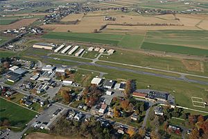
A view of Smoketown, including the Smoketown Airport
|
|
| Country | United States |
| State | Pennsylvania |
| County | Lancaster |
| Township | East Lampeter |
| Area | |
| • Total | 0.58 sq mi (1.50 km2) |
| • Land | 0.57 sq mi (1.48 km2) |
| • Water | 0.008 sq mi (0.02 km2) |
| Elevation | 358 ft (109 m) |
| Population
(2010)
|
|
| • Total | 357 |
| • Density | 623/sq mi (240.5/km2) |
| Time zone | UTC-5 (Eastern (EST)) |
| • Summer (DST) | UTC-4 (EDT) |
| ZIP code |
17576
|
| Area code(s) | 717 |
| FIPS code | 42-71504 |
| GNIS feature ID | 1198301 |
Smoketown is a small village and a special kind of community called a "census-designated place" (CDP) in Lancaster County, Pennsylvania, USA. It's part of East Lampeter Township. Sometimes people also call it Smoke Town. The village is known for being home to the Smoketown Airport. In 2010, about 357 people lived there.
Contents
Where is Smoketown Located?
Smoketown is in the eastern part of Lancaster County. It sits where two main roads meet: Pennsylvania Route 340 (Old Philadelphia Pike) and Pennsylvania Route 896 (Eastbrook Road).
Nearby Towns and Cities
To the east of Smoketown, you'll find the village of Bird-in-Hand. To the north, there's Witmer.
If you travel west on PA 340 for about 5 miles, you'll reach Lancaster. Lancaster is the main city and county seat. If you go east on PA 340 for the same distance, you'll arrive at Intercourse.
PA 896 leads south for about 1 mile to U.S. Route 30, also known as the Lincoln Highway. Continuing south on PA 896 for about 4 miles will take you to Strasburg.
Land and Water Features
The U.S. Census Bureau says that Smoketown covers a total area of about 1.5 square kilometers (about 0.6 square miles). Most of this area is land, with only a small part (about 0.02 square kilometers or 0.01 square miles) being water.
Mill Creek flows along the eastern edge of Smoketown. This creek helps form the border between Smoketown and Bird-in-Hand. Mill Creek eventually flows into the Conestoga River. The Conestoga River then joins the larger Susquehanna River. This means that the water in Smoketown is part of the huge Susquehanna River watershed.
Who Lives in Smoketown?
In the year 2000, Smoketown had a population of 119 people. At that time, the area was measured as 0.1 square miles. Most of the people living there, 115, were white. Four people belonged to two or more different races. There were 47 homes in the village, and on average, about 2.53 people lived in each home.
See also
 In Spanish: Smoketown para niños
 | Leon Lynch |
 | Milton P. Webster |
 | Ferdinand Smith |


