
Souris–Red–Rainy water resource region facts for kids
The Souris–Red–Rainy region is a special area in the United States. It's one of 21 big geographic areas that the United States Geological Survey uses to map out all the water. Think of it like dividing a big cake into slices! These areas help scientists understand where water flows.
This region is known by a special code: 09. It's super big, covering about 90,759 square miles (235,065 square kilometers). Inside this large area, there are three smaller parts, or "subregions," which have codes like 0901, 0902, and 0903.
The Souris–Red–Rainy region includes all the land in the U.S. where water flows into important rivers like the Rainy, Red, and Souris River. It also includes water that flows into the Lake of the Woods. All this water eventually makes its way to Lake Winnipeg and then to Hudson Bay in Canada! This region covers parts of Minnesota, North Dakota, and South Dakota.

Contents
Exploring the Souris–Red–Rainy Region
This large water region is split into three main parts. Each part helps manage the flow of water in different areas. Let's take a closer look at these subregions.
Souris Subregion (0901)
The Souris subregion is the first part of this big water area. It's mainly focused on the Souris River Basin within the United States. This subregion is located entirely in North Dakota. It covers about 9,150 square miles (23,699 square kilometers). Imagine all the land where rain and snow melt eventually flow into the Souris River – that's this subregion!
Red Subregion (0902)
The Red subregion is the biggest part of the Souris–Red–Rainy region. It includes the entire Red River Basin within the United States. This area also includes a unique place called the Devils Lake closed basin, where water flows in but doesn't flow out to other rivers. The Red subregion spreads across parts of Minnesota, North Dakota, and South Dakota. It's a huge area, about 39,800 square miles (103,081 square kilometers)!
Rainy Subregion (0903)
The Rainy subregion is the third part of this water region. It covers the land where water flows into the Rainy River and the Lake of the Woods within the United States. This subregion is found only in Minnesota. It's about 11,400 square miles (29,526 square kilometers) in size. This area is known for its beautiful lakes and forests.
Images for kids
-
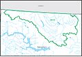
Map of the Souris subregion (0901).
-
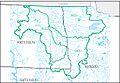
Map of the Red subregion (0902).
-
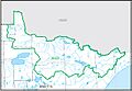
Map of the Rainy subregion (0903).


