South Barrule facts for kids
Quick facts for kids South Barrule |
|
|---|---|
| Baarool Jiass | |
 |
|
| Highest point | |
| Elevation | 483 m (1,585 ft) |
| Prominence | c. 338 m (1109 ft) |
| Listing | Marilyn |
| Naming | |
| English translation | Guard fell |
| Language of name | Old Norse |
| Geography | |
| Location | Isle of Man |
| OS grid | SC257759 |
| Topo map | OS Landranger 95 |
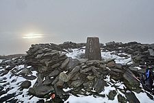
The South Barrule (Manx: Baarool Jiass) is the tallest hill in the southern part of the Isle of Man. It's a special place with a long history. On its very top, you can still see the remains of an old fort. People traditionally believed this fort was the home of a Manx sea god named Mannanan beg mac y Leir.
This hill is mostly surrounded by thick forests of conifer trees, which are often planted for wood. On the lower, southwestern side of the hill, there's a lake called the Cringle Reservoir. This reservoir was created to provide fresh water to the towns and villages in the southern part of the island. Long ago, South Barrule was known by different names, like Warfield or Wardfell.
Exploring South Barrule
A short, straight walking path connects the top of South Barrule to a lower area known as the Round Table. This "saddle" is a dip between two higher points. Several important routes pass through the Round Table. These include the Bayr ny Skeddan walking trail, the A27 road (which goes from Colby to Peel), and the A36 Sloc road.
Barrule in Manx Culture
Did you know there's also a North Barrule on the Isle of Man? The word "Barrule" (Manx: Baarool) is very important to the island. It even appears in the Manx national anthem. The anthem says the island is "firm as Barrule," meaning it is strong and steady, just like this mighty hill.
See also
 In Spanish: Barrule del Sur para niños
 | Shirley Ann Jackson |
 | Garett Morgan |
 | J. Ernest Wilkins Jr. |
 | Elijah McCoy |

