South Cape Mendocino State Marine Reserve facts for kids
Quick facts for kids South Cape Mendocino State Marine Reserve |
|
|---|---|

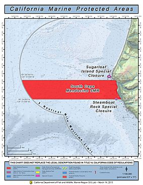
A map of the South Cape Mendocino State Marine Reserve and Sugarloaf Island special zone.
|
|
| Location | Humboldt County, California, USA |
| Nearest city | Ferndale, California |
| Established | December 19, 2012 |
| Visitors | zero, fully protected |
| Governing body | California Department of Fish and Wildlife |
The South Cape Mendocino State Marine Reserve is a special ocean area that protects marine life. It is located off Cape Mendocino in California, near the town of Petrolia. This reserve marks the westernmost point of California. It is a very natural and undeveloped part of the coast. Its waters are home to many important birds and sea animals. In this reserve, it is against the rules to take any living marine resources. This means fishing or collecting anything is not allowed.
Why is this Area Protected?
In June 2012, a group called the California Fish and Game Commission decided to protect these waters. They voted to make the South Cape Mendocino area a Marine Protected Area (MPA). This decision helped create the first network of underwater parks in the United States. These parks protect California's coast and important wildlife. They also help the state's tourism, hotels, and restaurants. These businesses depend on healthy fish and beautiful coasts to attract visitors. The South Cape Mendocino State Marine Reserve officially started on December 19, 2012.
What Animals Live Here?
The South Cape Mendocino State Marine Reserve protects many different kinds of animals. This includes various birds and seals. The area is a vital home and breeding spot for Steller sea lions. Its rocky areas are also perfect resting places for California sea lions. Many bird species also use this area for breeding. These include the Western gull, double-crested cormorant, Brandt's cormorant, and pelagic cormorant. Other birds like the black oystercatcher, pigeon guillemot, and tufted puffin also breed here.
Fun Things to Do Near the Reserve
The South Cape Mendocino area has tall rock cliffs and pebble beaches. It is a great place for many outdoor activities. People enjoy windsurfing here. You can also go tidepooling to see small sea creatures in the pools left by the ocean. It is also a good spot for watching wildlife. Hikers know this area as the start of the famous Lost Coast trail. Cyclists call one part of the cape "The Wall." This is because it has a very steep climb, which is a challenge for riders in the "Tour of the Unknown Coast."
 | James Van Der Zee |
 | Alma Thomas |
 | Ellis Wilson |
 | Margaret Taylor-Burroughs |


