
South Delhi facts for kids
South Delhi is an important area in the National Capital Territory of Delhi in India. It is a busy and well-known part of the city.
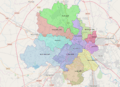
This area is surrounded by some key places. To the east, you'll find the Yamuna River. To the north, it borders New Delhi. The Faridabad District in Haryana state is to the southeast, and the Gurgaon District, also in Haryana, is to the southwest. To the west, it meets South West Delhi.
In 2001, about 2,258,367 people lived here. The total area of South Delhi is about 250 square kilometers. This means many people live close together, with about 9,034 people per square kilometer.
For managing the area, South Delhi is split into three smaller parts. These are called Saket, Hauz Khas, and Mehrauli.
When people talk about "South Delhi" in everyday life, they often mean a larger area. This bigger area stretches from Delhi's IGI Airport in the southwest all the way to the Yamuna river in the southeast. This wider idea of South Delhi even includes parts of the administrative South West Delhi district.
Who Lives in South Delhi?
According to the 2011 census, South Delhi had a population of 2,733,752 people. This number is similar to the entire country of Jamaica or the US state of Nevada. Out of all the districts in India (640 in total), South Delhi ranks 144th in population.
The area is very densely populated, with about 10,935 people living in each square kilometer. Between 2001 and 2011, the number of people living here grew by about 20.59%. For every 1000 males, there were about 859 females. Also, a high number of people can read and write, with a literacy rate of 87.03%.
Images for kids
-
A map showing the different districts of Delhi.

See also
 In Spanish: Distrito de Delhi sur para niños
