
South Fork Merced River facts for kids

The South Fork Merced River is a very important river in California. It is the biggest stream that flows into the Merced River. Most of this river runs through the beautiful Yosemite National Park. This park is located in the Sierra Nevada mountain range.
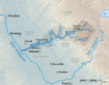
The South Fork Merced River is about 43 miles (69 kilometers) long. The area of land that drains water into this river, called its drainage basin, is about 240 square miles (620 square kilometers). A big part of this area, about 109 square miles (280 square kilometers), is inside Yosemite National Park. On average, the river carries about 356 cubic feet (10.1 cubic meters) of water every second where it joins the Merced River.
Where the River Begins
The South Fork Merced River starts high up in the mountains. It begins at about 10,600 feet (3,200 meters) above sea level. This starting point is on the south side of a mountain called Triple Divide Peak.
When it first begins, the river flows southwest. It travels through a forest filled with pine trees. On both sides, there are tall cliffs made of granite, a very hard rock.
The River's Journey
As the river continues, the valley walls get closer. The river then flows through a deep, narrow canyon. This canyon eventually opens up into a large, bowl-shaped valley. Here, the river passes by the northern part of a town called Wawona.
At Wawona, another stream called Chilnualna Creek joins the South Fork Merced River from the right side. The river then flows under Wawona Road. This road is the main entrance to Yosemite National Park from the south.
After Wawona Road, the river drops into another gorge. This gorge is wider and deeper than the first one. It runs north, and several other creeks join the river here. These include Alder, Rail, Big, and Bishop Creeks, all coming from the right.
Soon, the river turns west again. It leaves Yosemite National Park and enters the Sierra National Forest. Here, the land becomes foothills, which are lower hills at the base of the mountains. The South Fork Merced River then flows into the main Merced River. This meeting point is about 25 miles (40 kilometers) downstream from the end of Yosemite Valley.
A Naming Mix-Up
Back in 1871, there was a mistake on some maps. Reports from the California Geological Survey wrongly called this river "Illilouette Creek." However, Illilouette Creek is actually a different stream. It is another branch of the Merced River, located further to the east.
Images for kids
-
Merced River drainage basin
