South Mission Beach facts for kids
Quick facts for kids South Mission BeachQueensland |
|||||||||||||||
|---|---|---|---|---|---|---|---|---|---|---|---|---|---|---|---|

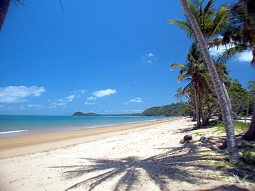
South Mission Beach looking south towards Lugger Bay, 2004
|
|||||||||||||||
| Population | 932 (2016 census) | ||||||||||||||
| • Density | 27.57/km2 (71.4/sq mi) | ||||||||||||||
| Postcode(s) | 4852 | ||||||||||||||
| Area | 33.8 km2 (13.1 sq mi) | ||||||||||||||
| Location | |||||||||||||||
| LGA(s) | Cassowary Coast Region | ||||||||||||||
| State electorate(s) | Hill | ||||||||||||||
| Federal Division(s) | Kennedy | ||||||||||||||
|
|||||||||||||||
South Mission Beach is a coastal town in Queensland, Australia. It is located in the Cassowary Coast Region. In 2016, about 932 people lived there. It's a beautiful place known for its long sandy beaches.
Where is South Mission Beach?
South Mission Beach is south of Mission Beach. However, the town of Wongaling Beach is actually between them. These three towns share a long sandy beach. This beach stretches for about 13 kilometres (8 miles). It faces the Coral Sea to the east.
The beach starts at Clump Point in Mission Beach. It goes all the way to Tam O'Shanter Point in South Mission Beach. Tam O'Shanter Point is a headland that creates two bays. To its north is Lugger Bay, and to its south is Kennedy Bay.
South Mission Beach is bordered by the Hull River to the south and southwest. A part of the North Hull River forms its northwestern border. Most of the land here is low and undeveloped. It is part of the Hull River National Park. There are some hills along the southeastern coast, reaching up to 120 metres (390 feet) high.
The main area where people live is along the northeast coast. This land is freehold, meaning people own it. The area of South Mission Beach also includes a former small town called Kenny.
There is only one road into the area, called South Mission Beach Road. This road connects to the larger Tully Mission Beach Road. That road then links up with the Bruce Highway near Tully.
A Look Back in Time
The land around South Mission Beach has a long history. It is the traditional home of the JiDjiru-speaking Aboriginal people. They were closely connected to other Aboriginal groups in the nearby rainforests.
Tam O'Shanter Point was named by Captain Owen Stanley in the 1800s. He named it after a ship called Tam O'Shanter. This ship was used by explorer Edmund Kennedy on a journey to North Queensland. Kennedy Bay was also named after Edmund Kennedy.
The first European settlers arrived in the wider area in the early 1900s. In 1912, the Reid family, Ben Beamon, and George Webb settled in what is now South Mission Beach.
In 1913, a large area of land on the Hull River was set aside. It became an Aboriginal Reserve, known as the Hull River Aboriginal Settlement. In 1914, John Martin Kenny became the leader of this settlement. It was located in the northern part of present-day South Mission Beach.
On March 10, 1918, a powerful cyclone hit the settlement. It destroyed the buildings and caused great tragedy. The superintendent, John Martin Kenny, and his daughter were killed. Twelve Aboriginal people from the settlement also lost their lives. Reports say over 400 Aboriginal people lived there at the time.
The Hull River settlement was not rebuilt after the cyclone. Many of the Aboriginal people were moved to Palm Island in 1918.
After the settlement closed, European settlers moved to the area to farm. For a long time, the main way to get there was by sea. In December 1938, a road was finally built from Tully to the Mission Beach area. A town was established in 1939 and named Kenny, in honor of John Martin Kenny. However, locals often called it South Mission Beach. So, on November 1, 1963, its name was officially changed to South Mission Beach.
Remembering the Past
A special monument, the Mija Memorial, was built to remember the victims of the 1918 cyclone. It was unveiled exactly 100 years later, on March 10, 2018.
 | James B. Knighten |
 | Azellia White |
 | Willa Brown |


