South Prairie, Washington facts for kids
Quick facts for kids
South Prairie, Washington
|
|
|---|---|

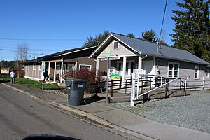
South Prairie Town Hall, February 2024
|
|

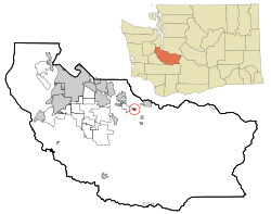
Location of South Prairie, Washington
|
|
| Country | United States |
| State | Washington |
| County | Pierce |
| Area | |
| • Total | 0.39 sq mi (1.01 km2) |
| • Land | 0.38 sq mi (0.99 km2) |
| • Water | 0.01 sq mi (0.02 km2) |
| Elevation | 430 ft (131 m) |
| Population
(2020)
|
|
| • Total | 373 |
| • Density | 1,156.66/sq mi (446.59/km2) |
| Time zone | UTC-8 (Pacific (PST)) |
| • Summer (DST) | UTC-7 (PDT) |
| ZIP code |
98385
|
| Area code | 360 |
| FIPS code | 53-66045 |
| GNIS feature ID | 1526307 |
South Prairie is a small town located in Pierce County, Washington, United States. It is a quiet community known for its natural surroundings. In 2020, the town had a population of 373 people.
Contents
History of South Prairie
South Prairie was first planned out in 1888 by Frank Bisson. When a town is "platted," it means its streets, blocks, and lots are officially mapped out. The town got its name because it was located south of two other areas called Connell's and Porter's prairies.
In 1885, the town's name was changed to "Cascade Junction." However, the people living there did not like this new name. They wanted to keep the original name. Because of their wishes, the town was officially named "South Prairie" again on February 17, 1909.
Geography and Location
South Prairie is located in Washington state. Its exact location can be described using coordinates: 47.138402 degrees North and -122.096848 degrees West. These numbers help pinpoint its spot on a map.
The United States Census Bureau measures the size of towns. South Prairie covers a total area of about 0.40 square miles (1.04 square kilometers). Most of this area is land, about 0.39 square miles (1.01 square kilometers). A very small part, about 0.01 square miles (0.03 square kilometers), is water.
Population and People
The number of people living in South Prairie has changed over the years. Here is a look at the population counts from different U.S. Censuses:
| Historical population | |||
|---|---|---|---|
| Census | Pop. | %± | |
| 1910 | 264 | — | |
| 1920 | 215 | −18.6% | |
| 1930 | 204 | −5.1% | |
| 1940 | 226 | 10.8% | |
| 1950 | 207 | −8.4% | |
| 1960 | 214 | 3.4% | |
| 1970 | 206 | −3.7% | |
| 1980 | 202 | −1.9% | |
| 1990 | 180 | −10.9% | |
| 2000 | 382 | 112.2% | |
| 2010 | 434 | 13.6% | |
| 2020 | 373 | −14.1% | |
| U.S. Decennial Census 2020 Census |
|||
Population in 2010
According to the 2010 census, there were 434 people living in South Prairie. These people made up 166 households. A household is a group of people living together in one home. Out of these, 115 were families.
The average number of people in each household was about 2.61. For families, the average size was about 3.15 people. The town had 174 housing units, which are places where people can live.
The median age of people in the town was 40.6 years old. This means half the people were younger than 40.6, and half were older. About 25.8% of the residents were under 18 years old. About 11.1% were 65 years old or older. The population was almost evenly split between males (51.8%) and females (48.2%).
See also
 In Spanish: South Prairie (Washington) para niños
 | Precious Adams |
 | Lauren Anderson |
 | Janet Collins |

