
Southernmost point buoy facts for kids

The Southernmost Point Buoy is a famous concrete buoy in Key West, Florida. It marks the southernmost spot in the continental United States. This means it's the land closest to the equator in the main part of North America. The buoy stands 18 feet above sea level.
The city of Key West put up this large, painted buoy in 1983. It quickly became a popular place for tourists to visit. Many people take photos with it, making it one of the most photographed spots in the United States.
Before the concrete buoy, a small sign marked this special spot. The concrete buoy has been strong enough to survive several hurricanes. It's a popular meeting place for visitors. Hurricane Irma damaged its paint in 2017. However, the original artist fixed it later that year. The city of Key West values this landmark as a top tourist attraction. Cuba is about 90 miles south of this point in Key West. This distance was added to the buoy later.
What is the Southernmost Point Buoy?

Before the big concrete buoy, a wooden sign showed the southernmost point. In 1970, this old sign simply said, "The Southernmost Point, of Southernmost City, Key West Fla." By 1982, the words changed to "The Southernmost Point, In USA, Key West Fla." There was also a separate sign nearby. It had an arrow pointing south and said, "90 Miles to Cuba."
.jpg)
The Key West Public Works Department takes care of the buoy. It was officially opened on September 10, 1983. This painted concrete buoy is 12 feet tall and 7 feet wide.
From here, you can start driving north on US 1. This road goes all the way to Fort Kent, Maine, in the far north. Next to the buoy is a small concrete building. This building was a telegraph hut. It held an underwater telephone cable that connected Key West to Havana in 1921. The cable went into the sea from this small structure.
As of 2011, the buoy has several phrases written on it. These include "The Conch Republic," "90 Miles to Cuba," and "Southernmost Point Continental U.S.A." It also says "Key West, F.L., Home of the Sunset." The buoy was repainted in 2005. The phrases "90 miles to Cuba" and "Home of the Sunset" were not on the buoy's paint job in 1986.
In November 1983, the buoy did not say "90 miles to Cuba." That phrase was still on a smaller sign on a fence nearby. Also, in 1983, the buoy did not include the words "Home of the Sunset." (You can see amazing sunsets at Mallory Square in Key West!)
By the 2010s, a webcam was set up. It shows live video of the street corner where the buoy is located. Danny Acosta, a local artist, painted the buoy. The City of Key West hired him to repaint it after Hurricane Irma damaged it in 2017.
Is the Southernmost Point Buoy the Real Southernmost Point?

The buoy is a famous landmark, but it's not the absolute southernmost point. There are other places that are actually farther south.
- Fort Zachary Taylor Historic State Park: A beach area in Fort Zachary Taylor Historic State Park is about 500 feet farther south than the buoy. This area is open to the public.
- Truman Annex: Land on the Truman Annex property is even farther south. It's about 900 feet south of the buoy. However, this land belongs to the United States Navy. Civilians cannot visit it.
- Ballast Key: The true southernmost point in Florida is actually 10 miles away. It's on a small island called Ballast Key. This island is south and west of Key West.
The buoy says "90 miles to Cuba." This might be a rounded number. Cuba is actually about 94 miles south at its closest point. Some people think the sign meant 90 nautical miles.
The original sign in 1970 said it was the Southernmost Point of the Southernmost City of Key West. Over time, as signs were replaced, more messages were added. This is how the buoy got all the text it has today.
Images for kids
-
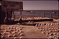
The spot was originally marked with sign, shown here in 1972
-
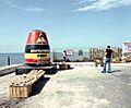
The buoy in the 1980s
-
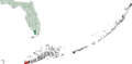
Key West in red on map is part of the Keys, with Monroe County in dark green on an inset map of the State of Florida
