
Southey, South Yorkshire facts for kids
Quick facts for kids Southey |
|
|---|---|
 Shown within Sheffield |
|
| Area | 1.8 sq mi (4.7 km2) |
| Population | 20,000 |
| • Density | 11,111/sq mi (4,290/km2) |
| Metropolitan borough | |
| Metropolitan county | |
| Region | |
| Country | England |
| Sovereign state | United Kingdom |
| EU Parliament | Yorkshire and the Humber |
| UK Parliament |
|
| Councillors | Anthony Damms (Labour Party) Mike Chaplin (Labour Party) Jayne Dunn (Labour Party) |
Southey ward is an important area in the northern part of Sheffield, England. It's one of the 28 "electoral wards" in the city. An electoral ward is like a local district that helps people choose their representatives for the city council.
This ward includes several smaller areas. These are Fox Hill, New Parson Cross, Southey, Wadsley Bridge, and part of Old Parson Cross. In 2011, about 19,086 people lived here in 8,295 homes. The ward covers an area of about 1.8 square miles (4.7 square kilometers). It is also part of the larger Sheffield Brightside and Hillsborough area, which chooses a Member of Parliament for the national government.
Contents
Exploring Southey Ward's Districts
Southey ward is made up of several unique districts. Each one has its own history and features.
Discovering Southey

Southey is a district in the northeast of Sheffield. It used to be a small village. Now, it's a busy area with lots of homes. Sadly, not much of the old village remains today. Some well-known spots in Southey include Southey Green and Cookson Park. In 2011, about 14,253 people called Southey home.
Exploring Birley Carr

Birley Carr is another part of Sheffield. It's located near Birley Edge, which is a natural cliff. At the top end of Birley Edge, you can find the Birley Stone. This stone might be what's left of an old Christian cross from the 1790s. The small area of Birley Edge also has some historic buildings. One of these is Birley Old Hall.
Visiting Fox Hill

Fox Hill is a residential area. It's named for being a hill that rises up from the A61 road. From Fox Hill, you can see great views towards the city center. The western side of the hill has a steep drop into the Don Valley. Fox Hill has a mix of private and council-owned homes. Many of these were built in the 1960s. There are also some green spaces. You can find a small row of shops opposite The Fox public house on Fox Hill Road.
Understanding Parson Cross
Parson Cross is a large residential area. It's mostly located in the Firth Park ward, which is a different part of Sheffield.
New Parson Cross
New Parson Cross is a housing estate within the Parson Cross area. It was built after the Second World War. This makes it different from the older "Old" Parson Cross estates. New Parson Cross has been updated and redeveloped in recent years. It is home to St Paul's Church, Wordsworth Avenue. This church was designed by a famous architect named Sir Basil Spence.
Discovering Wadsley Bridge
Wadsley Bridge is another district of Sheffield. It used to be a small village. It's located west of Southey. The area grew around what was once a place where people could cross the River Don.
Images for kids
-
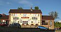
The Fox, a public house on Fox Hill Road
-
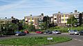
Modern homes on Fox Hill Crescent


